
Berniere, Henry de (sold)

Henry de Berniere (17?? - 1800) was an ensign and spy in the British Army’s 14th Regiment. Under the command of British General Gage, Captain William Brown and Berniere would disguise themselves as farmers or workers in civilian clothes and venture into the countryside and towns to spy on American battle preparations. Berniere, an artist, would sketch details of the area, and Brown was the logistics expert. They were responsible for helping British troops attack Concord in April 1775.
Rare American Revolutionary Era Battle Plan of the Battle on Bunker Hill.
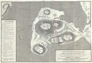
Sketch of the Action on the Heights of Charlestown June 17th 1775 between his Majesty's Troops under the command of Major Genl. Howe, and a Large Body of American Rebels.
sold
- Digital Map Information
- Suitable for large format printing
- Full resolution TIFF file
- ICC color profile embedded
- Delivered instantly via download link
This is an important 1818 map of the Battle of Bunker Hill, Charlestown, Massachusetts, by I. A. Charles. Copied from the original manuscript sketch by Henry De Berniere, which was apparently discovered in a trunk, it depicts the American Revolutionary War Battle ... (more details)