
Bernizet, Gérard Sébastien (sold)

Gérard Sébastien Bernizet (March 2, 1760 – May, 1788) was a French cartographer and geographical engineer. His best known for his work as chief cartographer on the La Perouse Expedition (1785 – 1789). Bernizet can be credited with many of the cartographic advances (and errors) associated with the expedition. The La Perouse expedition shipwrecked on the island of Vanikoro, part of the Santa Cruz group in the Solomon Islands. Although some of the sailors may have survived the initial shipwreck, none ever returned to Europe. The records of the La Perouse expedition survive because La Perouse prudently sent copies of his journals back to Europe onboard ad British Nave ship from the First Fleet (The Alexander) which he encountered en route.
One of the best large format 18th century maps of Hawaii.
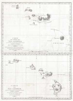
Carte des parties des Iles Sandwich, qui ont ete visitees aus mois de Mai 1786 par les Fregates Francaises la Boussole et l'Astrolabe / Carte des Iles Sandwich, assujettie aux observations faites a bord des Fregates Francaises la Boussole et l'Astrolabe.
sold
- Digital Map Information
- Suitable for large format printing
- DPI: 300
- File Size: 11.12 MB
- File Type: ZIP / TIFF
- ICC color profile embedded
- Delivered instantly via download link
A fine example of Jean François de Galaup, comte de La Pérouse and Gérard Sébastien Bernizet's map of Hawaii or the Sandwich Islands. Essentially two maps on a single sheet. The uppermost map details La Pérouse and Bernizet's shipboard surveys of the islands ... (more details)