
Bertelli, Ferrando (sold)

Ferrando Bertelli (c. 1525 - 1572) was an Italian engraver, living and working in Venice in the middle part of the sixteenth century. He is among the mot prolific of the map engravers collectively referred to as 'Lafreri School' mapmakers, whose elegant, rare, and distinctive maps are now among the most sought-after by collectors. Nothing is known of his education or training; he produced composite atlases in conjunction with Camocio, Forlani and Zenoi. His death in 1572 was almost certainly due to Venice's struggle with the plague, which appears to have disproportionately punished that city's printing trade.
One of the rarest, separately-issued 'Lafreri' style maps of Africa,
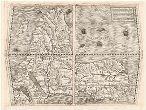
Prima Tavola.
sold
- Digital Map Information
- Suitable for large format printing
- DPI: 600
- File Size: 54.43 MB
- File Type: ZIP / TIFF
- ICC color profile embedded
- Delivered instantly via download link
This beautifully engraved map is Ferando Bertelli's map of Africa, in most respects closely copying the engraved 1563 map of Africa replacing the woodcut provided in 1554 by Giacomo Gastaldi for inclusion in Giovanni Battista Ramusio's Delle Navigationi et Viaggi when the blocks for that work were destroyed by fire. The map's title - Prima Tavola - is in reference to its place alongside a second map of Arabia and India (Seconda Tavola) and a third (Terza Tavola) of Southeast Asia. (The text box in the upper right describes the trio of maps as a sequence.) The map's southern orientation is the most obvious element setting it apart from other maps of Africa from this era, but it should be noted that this map shares that orientation with both others of the trio. The orientation of these three maps appears to have been Ramusio's decision: perhaps the presentation of Africa as viewed from Europe, and in progression from west to east, suited Ramusio's narrative collection of voyages better than following the Ptolemaic convention of having north to the top. Gastaldi's own maps of these regions were oriented to the north, and the other maps appearing in Ramusio's Viaggi - showing west Africa, Sumatra, Brazil, and New France - all adhered to a traditional northern orientation. (more details)