
Bruckner, Isaak (sold)

Isaak Bruckner (July 23 1686 - April 6 1762) was a Swiss buckle maker, stonecutter, machinist and mapmaker. The son of a pastor, he undertook a number of apprenticeships as a clasp and belt maker, a stone cutter and finally as a mechanic. He was accepted into the Basel guild for that trade in 1712. It was this line of work that eventually brought him instrument making, and eventually to mapmaking: In 1722 he constructed his first globe, developing it until 1725. He traveled to Paris in 1725 to present one of his beautiful gilt-copper globes to the Académie des sciences, which was well enough received for him to be appointed a corresponding member of the academy, and to be made a royal geographer to Louis XV. Leonhard Euler invited Bruckner to the Saint Petersburg Academy of Sciences in 1733. There, he taught mechanics and produced instruments and maps, including a sundial (on whose use he also published a pamphlet in 1735). He would leave the Academy in 1745, traveling throughout Europe. He produced his most impressive printed cartographic work in 1749 under the auspices of the Academy of Sciences in Berlin. In 1752 he returned to Basel, to lecture on geography, mechanics and geometry at the University of Basel. In 1754 and 1755 he and his colleague Daniel Bernoulli created a world map and a globe; iterations of the map appeared in Didot's encyclopedia and would be copied by various publishers.
State-of-the-Art Cartography of the 'Akademiya Nauk', published (instead) by the Berlin Royal Academy of Science
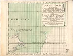
Carte Marine de la Mer Glaciale avec une Partie de la Province de Jrkucki 1749.
sold
- Digital Map Information
- Suitable for large format printing
- Full resolution TIFF file
- ICC color profile embedded
- Delivered instantly via download link
This is a rare 1749 map of the Bering Strait by Issak Bruckner (Issac Brouckner on the map). It is a remarkable and important artifact of 18th century cartography, illustrating the vectors by which secret cartographic data passed from the Russian Academy to the west, specifically to the Royal Academy of Sciences in Berlin under the auspices of Field Marshall Count Samuel von Schmettau, (to whom the map was dedicated). The map is one of twelve sheets executed by the Swiss instrument maker and geographer Bruckner, whose decade as Master of Instruments and globemaker for the Russian Academy of Sciences granted him astonishing access to the latest, secret Russian Naval maps of the northeast Russian coastline. Count von Schmettau opened the Royal Academy's archives to Bruckner, who would synthesize that information along with his own to produce the Nouvel Atlas de Marine, a meticulous twelve-sheet map of the world which Philips would hail as the first Prussian marine atlas. (Phillips, Atlases, 4146). (more details)