
Bureau of Ethnology (sold)

The Bureau of Ethnology (1879 - 1965) was a bureau of the United States government tasked with transferring the records, archives, and other materials relating to Native Americans from the Interior Department to the Smithsonian Institution. The bureau's visionary founding director, John Wesley Powell, saw the bureau's mission as a much broader endeavor. He believed from the start that the bureau's mission was 'to organize anthropologic research in America'. Under Powell's leadership, the bureau sponsored ethnographic, archaeological, and linguistic field research; organized research-intensive multi-year projects; promoted the fledgling discipline of anthropology; and initiated publication series, including its Annual Reports and Bulletins. The bureau also collected anthropological samples for the Smithsonian United States Museum and prepared exhibits for expositions. The bureau's name changed in 1897 to the Bureau of American Ethnology, indicating the scope of its work, and in 1965 the Bureau of American Ethnology merged with the Smithsonian's Department of Anthropology to for the Smithsonian Office of Anthropology within the United States National Museum (today known as the Department of Anthropology, National Museum of Natural History).
Illustrates the many land cessions from the Cherokee Indians to the American Colonies and then the United States government in the 18th and 19th centuries.
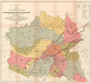
Map of the former Territorial Limits of the Cherokee 'Nation of' Indians Exhibiting the Boundaries of the Various Cessions of Land Made by Them to the Colonies and the United States by Treaty Stipulations. From the Beginning of Their Relations with the Whites to the Date of Their Removal West of the Mississippi River.
sold
- Digital Map Information
- Suitable for large format printing
- File Size: 45.44 MB
- File Type: ZIP / TIFF
- ICC color profile embedded
- Delivered instantly via download link
This is an 1884 Charles C. Royce map of the cessions of the former lands of the Cherokee Indians before they were removed west of the Mississippi. The map depicts the region from west of the Tennessee River to Virginia, North Carolina, and South Carolina, and from the Ohio River to Alabama, Georgia, and South Carolina. Thirty-six different cessions, dating from the colonial period through the 1830s, are traced here, each numerically identified and shaded a different color to allow for easier differentiation. These numbers correspond with an index situated in the upper right corner which provides the viewer with the date and designation of the treaty, a description of the cession, and the color it is shaded. This creates a visual summary of how the Cherokee lost this land during the 18th and 19th century before ultimately being forcibly relocated to lands west of the Mississippi.
These cessions are superimposed on a map that also labels the cities, towns, rivers, and mountain ranges, allowing viewers to have a better understanding of the geography of the cessions in relation to 'modern-day' landmarks. Nashville, Frankfort, Louisville, Lexington, Atlanta and Cincinnati are all identified. The 'Old Road from Nashville to Falls of Ohio' and the 'Old Road from Nashville to Lexington' are both illustrated, along with several others, including 'General Jackson's Old Military Road' and the 'Route of General Robertson's Expedition Against the Indians'. (more details)
These cessions are superimposed on a map that also labels the cities, towns, rivers, and mountain ranges, allowing viewers to have a better understanding of the geography of the cessions in relation to 'modern-day' landmarks. Nashville, Frankfort, Louisville, Lexington, Atlanta and Cincinnati are all identified. The 'Old Road from Nashville to Falls of Ohio' and the 'Old Road from Nashville to Lexington' are both illustrated, along with several others, including 'General Jackson's Old Military Road' and the 'Route of General Robertson's Expedition Against the Indians'. (more details)