
Imprimerie Chaix (sold)

Imprimerie Chaix (1845 - 1965) was a French publishing firm based at 20 Rue Bergère in Paris. They are best known for printing and publishing Belle Époque posters, including the celebrated Les Maîtres de l'Affiche. Les Maîtres de l'Affiche was a highly influential art publication featuring the Belle Époque commercial posters. Based upon a monthly subscription system, members received four prints each month over a five year period, resulting in 240 images along with 16 bonus images.
Goan economic revival.
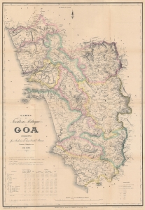
Carta do Territorio Portuguez de Goa Correcta port jose Frederico d'Assa Castel Branco.
sold
- Digital Map Information
- Suitable for large format printing
- Full resolution TIFF file
- ICC color profile embedded
- Delivered instantly via download link
This is an impressive large-scale 1878 first-edition map of Goa by Goa-born military engineer José Frederico d'Assa Castel-Branco. It represents a revolution in the cartographic knowledge of Goa and the finest trigonometrical map of Goa to appear in the 19th century. It was made in response to the signing of the Anglo-Portuguese Treaty of 1878, a major economic treaty that saw massive infrastructure development and the revitalization of the Goan economy after nearly 100 years of isolation and stagnation. (more details)
An extremely rare French broadside promoting the Sao Paulo-Rio Grande Railway in Brazil.
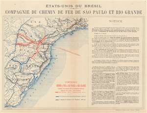
États-Unis du Brésil: Compagnie du Chemin de Fer de São Paulo et Rio Grande.
sold
- Digital Map Information
- Suitable for large format printing
- File Size: 17.52 MB
- File Type: ZIP / TIFF
- ICC color profile embedded
- Delivered instantly via download link
This is a c. 1900 broadside promoting investment in Brazil's São Paulo-Rio Grande Railway. Written in French and published by the Imprimerie Chaix in Paris, a map of the Brazilian coastline from Rio de Janeiro, Brazil to Montevideo, Uruguay occupies the left portion of the broadside. Cities, towns, and villages are identified, but the focus of the work is the planned construction of the Compagnie du Chemin de Fer de São Paulo et Rio Grande (Sao Paulo-Rio Grande Railway Company) between Itarare to the Uruguay River with two spur lines to the Parana River. Illustrated in orange, lines operated by the Compagnie du Chemin de Fer de São Paulo et Rio Grande would connect with lines operated by the Compagnie Générale du Chemins de Fer Brésiliens (General Brazilian Railway Company) and the Compagnie des Chemins de Fer Sud-Ouest Brésiliens (Southwest Brazilian Railway Company). The routes of the Compagnie Générale du Chemins de Fer Brésiliens are shown here in black, while the lines operated by the Compagnie des Chemins de Fer Sud-Ouest Brésiliens are blue. (more details)