
Chambon, Gobert-Denis (sold)

Gobert-Denis Chambon (? - 1781) was a French map engraver and geographer active in Paris during the mid-to-late 18th century. His work encompassed decorative geographical maps and the specialized engraving of map lettering. In 1754, he engraved maps of Africa and America published in Paris by Longchamps and Jean Janvier; examples incorporated elaborate borders with historical narrative scenes, combining geographical information with accounts of the origins and histories of peoples and kingdoms. Chambon also contributed to the Carte générale de la France directed by César-François Cassini de Thury (1714 - 1784). The Lyon sheet, published in 1760 - 1761, distinguishes his lettering from the map engraving undertaken by Nicolas Chalmandrier, illustrating the division of labor within this major cartographic enterprise. In 1776, Chambon was recorded as a taille-douce engraver residing on the rue Saint-Jean-de-Beauvais in Paris. His later work included the lettering for Longchamps fils's map of the Senegal and Gambia rivers, published in 1779, on which Tulpin was separately credited as engraver. Chambon died in 1781.
Dramatic Sea of the West.
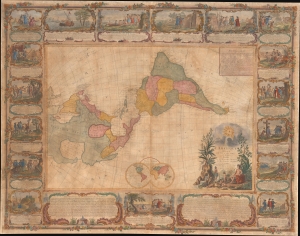
L'Amerique Divisee En Tous Ses Pays Et Etats dressée sur de nouveaux Memoires et sur les derniers Observations.
sold
- Digital Map Information
- Suitable for large format printing
- File Size: 185.45 MB
- File Type: ZIP / TIFF
- ICC color profile embedded
- Delivered instantly via download link
This is a dramatic 1754 east-oriented wall map of the Americas by Jean Janvier and Sebastian G. Longchamps - better known as Voltaire's valet. The dramatic map includes one of cartography's boldest iterations of the Sea of the West. This map appeared at the outset of the French and Indian War (1754 - 1763) and correspondingly details France's bold claims to much of North America. (more details)
American colonies at the outset of the Revolutionary War.
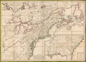
Carte des Possessions des Colonies Anglaises dans le Continent de L'Amérique Septentrionale et Partie de la Louisiane.
sold
- Digital Map Information
- Suitable for large format printing
- File Size: 185.45 MB
- File Type: ZIP / TIFF
- ICC color profile embedded
- Delivered instantly via download link
This is the 1776 edition of Sebastian G. Longchamps's map of eastern North America, published at the outset of the American Revolutionary War (1775 - 1783) to capitalize on popular French interest in the conflict. The map was first issued in 1756, during the French and Indian War (1754 - 1763), but has here been revived with significant new engraving, additional relevant details, and a new title to illustrate the opening theaters of the American Revolution. Key revisions give greater prominence to the individual New England colonies and expand the coastal nomenclature of northern Newfoundland, where France retained valuable fishing privileges despite losing Canada. (more details)