
C.J. Peters and Son Company (sold)

C.J. Peters and Son Company (fl. c. 1855 - 1920) was an an American typography, electrotyping, engraving, printing, and stereotyping firm active in Boston during the 19th and 20th centuries. The firm produced a wide range of products.
The Most Climbed Mountain in America
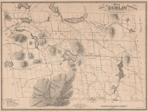
Map of the Town of Dublin New Hampshire including the Part Set Off to the Town of Harrisville.
sold
- Digital Map Information
- Suitable for large format printing
- File Size: 49.02 MB
- File Type: ZIP / TIFF
- ICC color profile embedded
- Delivered instantly via download link
This is a scarce 1906 map of the town of Dublin, New Hampshire, prepared a half-century earlier by Thomas Fisk and updated by Samuel Wadsworth. Among other features, it is notable for its careful detail of Mount Monadnock, the most prominent peak in southern New Hampshire. (more details)
Highlights an extensive street trolley network.
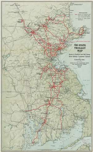
Tri-State Trolley Map Showing Boston and Northern and Old Colony Street Railway Companies' Systems and Connecting Lines.
sold
- Digital Map Information
- Suitable for large format printing
- File Size: 19.49 MB
- File Type: ZIP / TIFF
- ICC color profile embedded
- Delivered instantly via download link
This is a 1907 C.J. Peters and Son map of Massachusetts, New Hampshire, and Rhode Island trolley lines. Thick red lines trace the Boston and Northern and Old Colony Street Railway Companies' routes throughout the region from Newburyport, Massachusetts south to Newport, Rhode Island. Thin black lines follow other street railway routes, allowing viewers a more general understanding of the street railway network in this part of the United States around the turn of the 20th century. Cities and towns along these routes are labeled. Among the cities served by these two railways are Boston, Providence, Newport, Salem, Marblehead, and Nashua. Lakers and rivers are illustrated and shading is used to subtly include the region's topography. (more details)