
Clüver, Philipp

Philipp Clüver (also Klüwer, Cluwer, or Cluvier, Latinized as Philippus Cluverius and Philippi Cluverii) (1580 - December 31, 1622) was a German geographer and historian active in Leiden in the late 16th and early 17th centuries. Clüver was born in the Royal Prussian city of Danzig (Gdansk), then a province of the Kingdom of Poland. He study of law at the University of Leiden before turning his attention to history and geography. Cluver traveled, mostly by foot, extensively throughout Europe, spending time in Germany, England, Scotland, Holland and Italy. On returning to Leiden he was given a special appointment as geographer and put in charge of the university's library. Cluver is best known for his general study of the geography of antiquity. A popular Enlightenment era field of study, antiquarian geography attempted to resolve place names known from classical literature but, by the time of the Renaissance, geographically confused. Cluver based his research not only on classical literary sources, but — and this was his primary contribution to the genre — also his extensive and local inspections of sites. Today he is considered one of the founding fathers of historical geography. Cartographically Cluver's most prominent works include his edition of Ptolemy's Geographia (based on Mercator's edition of 1578) and for miniature atlases that were reprinted for most of the 17thand 18th centuries. Cluver was also known as Klüwer, Cluwer, or Cluvier, Latinized as Philippus Cluverius and Philippi Cluverii. He died in Leiden in 1622.
Miniature map of the Classical Sicily.
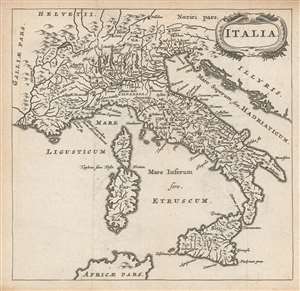
Italia.
$250.00
Acquire
- Digital Map Information
- Suitable for large format printing
- DPI: 600
- File Size: 3.45 MB
- File Type: ZIP / TIFF
- ICC color profile embedded
- Delivered instantly via download link
This is a finely-engraved miniature map of Italy, with Sicily, Sardinia and Corsica, printed in a 1661 Elzevir edition of Philipp Clüver's Introductionis in Universam Geographiam. The map shows place names drawn from of antiquity, derived from classical sources, including Pliny, Strabo, and Julius Caesar. It therefore depicts the Italy known to Ancient Rome. Mountains are indicated pictorially. (more details)
Miniature map of the Classical Sicily.
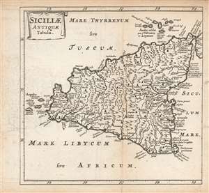
Siciliae Antiquae Tabula.
$275.00
Acquire
- Digital Map Information
- Suitable for large format printing
- Full resolution TIFF file
- ICC color profile embedded
- Delivered instantly via download link
This is a finely-engraved miniature map of Sicily and its adjacent islands, printed in a 1661 Elzevir edition of Philipp Clüver's Introductionis in Universam Geographiam. As is implied in the title, the map shows the Sicily of antiquity, derived from classical sources, including Pliny, Strabo, and Julius Caesar. It therefore depicts the Sicily known to Ancient Rome. Thus Mount Aetna includes the Temple of Vulcan: and the Fretum Siculum (the strait separating Sicily and the Italian Peninsula) is marked with the locations of Scylla and Carybdis, the dual navigational menaces featured in Homer's Odyssey. Forests and mountains are indicated pictorially. (more details)
Miniature map of the British Isles under the Roman Empire.
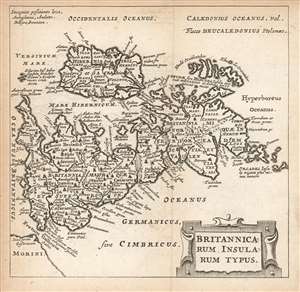
Britannicarum Insularum Typus.
$275.00
Acquire
- Digital Map Information
- Suitable for large format printing
- Full resolution TIFF file
- ICC color profile embedded
- Delivered instantly via download link
This is a finely-engraved miniature map of the British Isles, printed in a 1661 Elzevir edition of Philipp Clüver's Introductionis in Universam Geographiam. This westward-oriented map follows the model of Abraham Ortelius' 1595 map of the same title. As with the Ortelius, this map presents modern geographical information (the outline follows that of Mercator's 1564 and Saxton's 1579 maps) but employs toponomy derived from classical sources, including Pliny, Strabo, and Julius Caesar. It therefore depicts the Britain known to Ancient Rome - Britannia - divided into its Imperial provinces. Celtic tribal names are given as well. The Roman walls built by Hadrian and Antoninus Pius are shown, and historical details, such as Caesar's landing site in his 55 BCE invasion are marked as well. Forests and mountains are indicated pictorially. (more details)
Attractively Engraved Map of the African Continent.
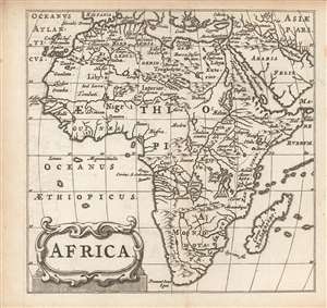
Africa.
$250.00
Acquire
- Digital Map Information
- Suitable for large format printing
- Full resolution TIFF file
- ICC color profile embedded
- Delivered instantly via download link
This is a finely-engraved miniature map of Africa, printed in a 1661 Elzevir edition of Philipp Cluver's introduction to geography. Cluver's work appeared in editions produced by many different houses, and with maps of wildly differing characteristics. (more details)
The Far East.
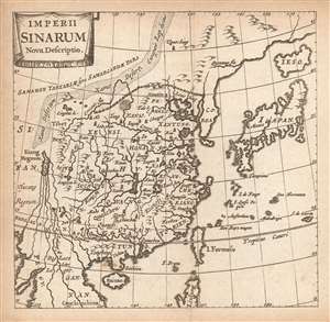
Imperii Sinarum Nova Descriptio.
$250.00
Acquire
- Digital Map Information
- Suitable for large format printing
- Full resolution TIFF file
- ICC color profile embedded
- Delivered instantly via download link
This is a finely-engraved miniature map of China, Korea and Japan, printed in a 1661 Elzevir edition of Philipp Cluver's introduction to geography. Cluver's work appeared in editions produced by many different houses, and with maps of wildly differing characteristics. (more details)
South Italy as it was known in ancient times!
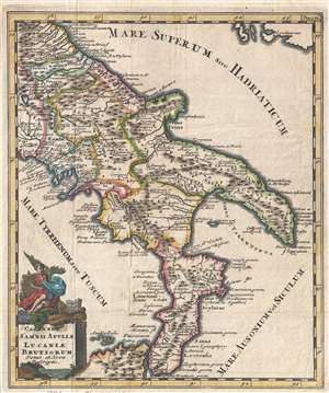
Campaniae, Samnii Apuliae Lucaniae Brutiorum Vetus et Nova Descriptio.
$275.00
Acquire
- Digital Map Information
- Suitable for large format printing
- Full resolution TIFF file
- ICC color profile embedded
- Delivered instantly via download link
An uncommon 1729 Philipp Clüver map of southern Italy in antiquity. The map covers from the Lago di Bolsena to the southernmost boot of Italy, including parts of northern Sicily and from the Tyrrhenian Sea to the Adriatic. Place names, as they were known in ... (more details)