
Colles, Eliza (sold)

Elizabeth Colles (1775 - 1799) or Eliza, was an American engraver of Irish descent, the daughter of visionary inventory and mapmaker, Christopher Colles. She was the first American female map engraver. Working for her father, Eliza engraved many of the plates for A Survey of the Roads of the United States, the first American road book, and the unpublished/unfinished Geographical Ledger (New York plate, Canada/Vermont Plate, and the two diagrams in the index). Eliza was probably taught engraving by either her father or Cornelius Tiebout, and appears to have become involved with the Colles Survey of Roads at just 13 years of age, when her father, Christopher Colles, had a falling out with Tiebout. Her name is often represented as Eliza Coles. Elizabeth died at 23 or 24, probably in the 1799 Yellow Fever Epidemic.
Exceptional complete example of the First American Road Atlas!
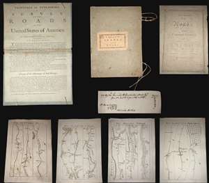
A superb example, entirely complete, of Christopher Colles' 1789 - 1790 A Survey of the Roads of the United States of America. This is the First American Road atlas, wherein at least some of the plates represent the first American maps engraved by a female - Colles' 13-year-old daughter Eliza. Covering depictions from Albany, New York to Williamsburg, Virginia, Colles' atlas consists of a prospectus, a title page, and 83 separate strip maps, each covering some 12 miles of roads and offering invaluable detail about the natural and human landscape of late 18th-century America, and was published in commemoration of the founding of the new republic in 1789. (more details)
Most complete extant example of Christopher Colles' 1794 unpublished and unfinished magnum opus.
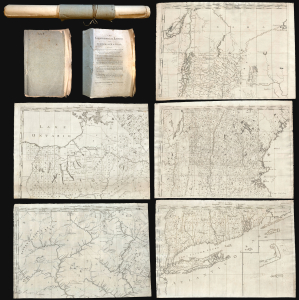
The Geographical Ledger.
sold
- Digital Map Information
- Suitable for large format printing
- Full resolution TIFF file
- ICC color profile embedded
- Delivered instantly via download link
The most complete extant example of Christopher Colles' 1794 unpublished and unfinished magnum opus, The Geographical Ledger, a loose-leaf indexed atlas of the United States whose sheets could be combined into a single enormous map. While not the first large-format American map, the Ledger, even unfinished, is unprecedented in its size and detail, and is the first general map to identify such items as early American forges (furnaces), mills, roads, farmsteads, property owners, roadside inns, fledgling settlements, early county configurations, etc. Although Colles is better known for his publication of the seminal 1790 Survey of the Roads, The Geographical Ledger was a work of boundless ambition that exceeded not only Colles' meager funds, but also the needs and values of the time. Nonetheless, the Ledger, even though unfinished, stands out as the masterwork of an unrecognized genius in pursuit of grandiose visions ahead of his time. (more details)