
Deur, Abraham (sold)

Abraham Deur (1666 - 1714) was a Dutch engraver based in Amsterdam. Little is known of his life, or that of his two sons Jacob and Jan, who do not appear to have carried the business beyond their father's death. Abraham engraved maps for a number of prominent Amsterdam publishers, including Goos, Mortier, Schenk, Visscher and De Wit.
Rare, High Baroque Double Hemisphere World Map, with Allegorical Vignettes.
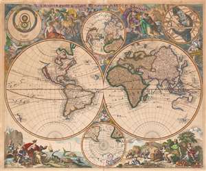
Haemisphaeriorum Tabula Carthesiana P. Schenkii.
sold
- Digital Map Information
- Suitable for large format printing
- Full resolution TIFF file
- ICC color profile embedded
- Delivered instantly via download link
Rare. This is a c. 1700 Pieter Schenk map of the world in a double hemisphere projection. The map draws on a number of 17th century sources - the insular California and the tentative coastline of the Pacific Northwest derive from Sanson; the depiction of Abel Tazman's discoveries in Australia and the South Pacific resembles that of Blaeu and De Wit; there is considerable influence from Carel Allard's map of 1696 as well, particularly in the inclusion of the Great Lakes in North America, and a Hennepin-type Mississippi River with its outlet in the vicinity of Galveston Bay. The map includes the La Salle expedition Fort Prudhomme on the Mississippi, the first French settlement in what would become Tennessee. Unlike Allard's map (and Schenk's own 1706 world map), the present composition contains considerable decorative flourish. There are putti nestled in the cruxes of the two hemispheres: the southern one puffing a flowery wind, and the northern one brandishing a star, which may be the North Star. Above and below the cruxes of the main hemispheres are a pair of polar projections illustrating the parts of the globe least understood until well into the 19th century. (more details)