
Johannes van Doetecum I (sold)

Johannes van Doetecum I (1528/32 - 1605, also spelled Duetecom, Duetecum, van Doetechum) was the patriarch of a Durch family of etchers and engravers, originally from Deventer. With his brother Lucas (died c. 1589), Johannes moved to Antwerp where they would work for a variety of publishers, inclufing Hieronymus Cock and Gerard de Jode. Their oeuvre included etched landscapes and ornamental work, but they are perhaps best known for the maps they produced not only for De Jode but also for Lucas Waghenaer, Petrus Plancius, and Linschoten.
Flawless example of one of the earliest modern maps of the East Indies.
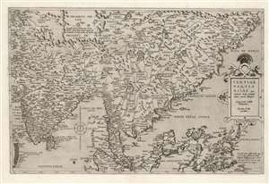
Tertiae Partis Asiae quae modernis India orientalis dicitur acurata delineatio Autore Iacobo Castaldo Pedemontano. Gerardus de Iode excudebat.
sold
- Digital Map Information
- Suitable for large format printing
- Full resolution TIFF file
- ICC color profile embedded
- Delivered instantly via download link
This is a flawless example of the rare 1578 first edition of Gerard De Jode's map of India, the East Indies, and the Philippines. It is broad in scope, including all of India, most of China, the Philippine Islands, and the Malay Peninsula. Singapore appears under the name 'Cingatola.' (more details)
Earliest View of a strategic waypoint on maritime routes to the Far East.
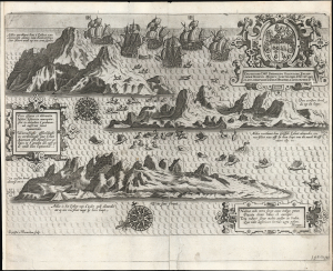
Vera effigies et delineatio insulae. Ascenscio nuncupatae... Waerachtighe affbeeldinghe en verthooninghe vant eylant Asçençion...
sold
- Digital Map Information
- Suitable for large format printing
- Full resolution TIFF file
- ICC color profile embedded
- Delivered instantly via download link
This is Jan van Linschoten's 1596 view of Ascension Island - considered the earliest printed depiction of Ascension Island in the South Atlantic. This view derives from Linschoten's firsthand observation: his narrative of his return to Europe from India describes the approach to the island, sailing northwest from the Cape of Good Hope, the abundance of the island's fish (including flying fish smacking into the ships), and the fleet's continued journey to Cape Verde and the Canaries. (more details)