
Edsall, David A. (sold)

David A. Edsall (fl. c. 1877 - c. 1878) was a New York City based inventor, publisher, printer, and lithographer active in the late 19th century. Edsall issued commercial maps of New York City and Chicago. He filed a patent in 1875 for a rack-pad stamp-inking apparatus. He maintained offices at 14 Broadway and later 233 Broadway. In 1879 Edsall's plates were taken over by S. D. L. Taunton who continued to republish them under his own imprint. D. A. Edsall may have been born in Elmira, New York, and during the American Civil War, served as a member of the Union Regiment. If so he saw action at Bull's Run.
Highlights mass transit in New York City including the Elevated Railroad and the Street Horse Cart Railroads.
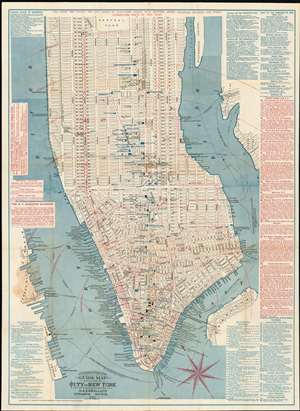
Citizens and Travelers Guide Map in, to and from the City of New York and Adjacent Places.
sold
- Digital Map Information
- Suitable for large format printing
- File Size: 35.85 MB
- File Type: ZIP / TIFF
- ICC color profile embedded
- Delivered instantly via download link
This is the sole 1877 edition of this Edsall and Company map of New York City drawn to promote the Adams Express Company, a 19th-century freight and cargo transport business which remains as one of the oldest companies still listed on the New York Stock Exchange. The map depicts Manhattan from 63rd Street to The Battery and from the Hudson (North) River to Hunter's Point, Green Point, and Brooklyn. The map's role in promoting a shipping company is reflected in the map's meticulous depiction of the city's growing transit system, providing the reader a visceral sense of the burgeoning, busy city as it developed. The Elevated Railroad, which ran every eight minutes from South Ferry along Ninth Avenue to 59th Street is shown, along with sixteen different lines of the Street Horse Car Railroad. As the name suggests, the Street Horse Car Railroad consisted of carts running on rails pulled by horses. Several different companies operated on certain lines, and these cars were a much more pleasant form of transport and sheltered customers from the elements. Each of these lines, the Elevated Railroad and the Street Horse Cart Railroads, are illustrated by red lines snaking their way through the streets. The Hudson River Railroad, which left Pennsylvania Station and ran along Eleventh Avenue, is illustrated by black railroad tracks, as are the New York, New Haven and Hartford Railroad and the New York Central and Hudson Railroad, which left from Grand Central.
Numerous locations throughout Manhattan are labeled, including City Hall, County Court, Trinity Church, and Bellevue Hospital. Other locations are labeled by blue overprinting, including Tiffany and Company's location at Union Square, several different Delmonico's Restaurant locations, and numerous hotels. The Brooklyn Bridge, which was in the process of being built, is illustrated across the East River and labeled simply 'Suspension Bridge'. Information provided along the left and right borders includes the operating schedule and fare rates for the New York Elevated Railroad, departure points for five different railway companies that take travelers out of the city, information concerning ferries across the North and East Rivers and international steamship departure piers. Routes of the Street Horse Car Railroad are also provided, along with information about hotels, both on the American and European plan. (more details)
Numerous locations throughout Manhattan are labeled, including City Hall, County Court, Trinity Church, and Bellevue Hospital. Other locations are labeled by blue overprinting, including Tiffany and Company's location at Union Square, several different Delmonico's Restaurant locations, and numerous hotels. The Brooklyn Bridge, which was in the process of being built, is illustrated across the East River and labeled simply 'Suspension Bridge'. Information provided along the left and right borders includes the operating schedule and fare rates for the New York Elevated Railroad, departure points for five different railway companies that take travelers out of the city, information concerning ferries across the North and East Rivers and international steamship departure piers. Routes of the Street Horse Car Railroad are also provided, along with information about hotels, both on the American and European plan. (more details)
Highlights mass transit in New York City including the Elevated Railroad and the Street Horse Cart Railroads.
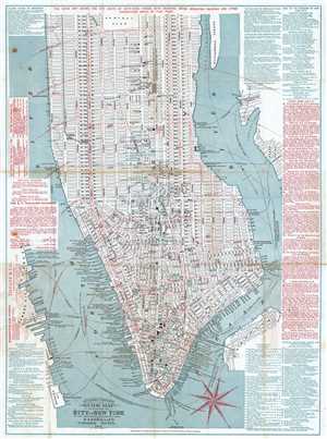
Citizens and Travelers Guide Map in, to and from the City of New York and Adjacent Places.
sold
- Digital Map Information
- Suitable for large format printing
- File Size: 15.62 MB
- File Type: ZIP / TIFF
- ICC color profile embedded
- Delivered instantly via download link
This is an 1877 D. A. Edsall and Company city map or plan of New York City drawn to promote 'Adams Express Company'. The map depicts Manhattan from 63rd Street to The Battery and from the Hudson (North) River to Hunter's Point, Green Point, and Brooklyn. An ... (more details)