
Fisher, Joshua (sold)

Joshua Fisher (1707 - January 31, 1783) was an American hatter, merchant, politician, and a self-taught surveyor. Born in Delaware, Fisher married Sarah Rowland in 1733 and the couple settled down in Lewes, Delaware. Risher and his wife moved to Philadelphia in 1746, where he opened a general store. Upon his move to Philadelphia, Fisher carried with him several letters of introduction from friends and neighbors in Delaware proclaiming him to be a quiet, peaceable neighbor and 'a worthy Honest Man'. While living in Delaware, Fisher served as the coroner of Sussex County and as the deputy-surveyor of Delaware. =
A French edition of Joshua Fisher's chart of Delaware Bay, considered to be one of the most important maps of the vicinity of Philadelphia ever produced.
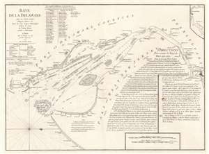
Baye de la Delaware Avec les Ports, Sondes, Dangers, Bancs, etc. depuis les Caps Jusqu'a Philadelphie d'Après la Carte de Joshua Fisher publiée a Philadelphie.
sold
- Digital Map Information
- Suitable for large format printing
- DPI: 600
- File Size: 28.52 MB
- File Type: ZIP / TIFF
- ICC color profile embedded
- Delivered instantly via download link
This 1777 George-Louis Le Rouge nautical chart or maritime map of Delaware Bay is a French edition of a near unobtainable chart by the self-taught Philadelphia cartographer Joshua Fisher. The chart depicts the region from just south of Cape Henlopen (labeled here as Cape James) to Philadelphia and from Delaware to Cape May and the Atlantic Ocean. Channels, shoals, ledges, flats, and other navigational hazards are illustrated, as are several different channels, all of which are labeled. Depth soundings are included along each of these channels as well. Coastal landmarks are identified, including both Cape Henlopen and Cape May with their latitudes noted. An inset of the waterway above Philadelphia is situated in the upper right corner. Detailed navigational instructions for the bay are included in the bottom right quadrant. (more details)