
Flahaut, Jacques-Michel (sold)

Jacques-Michel Flahaut (1791 - March 20, 1864) was a Paris-based French engraver active in the middle part of the 19th century. Flauhat was born in Paris and worked extensively in Paris mapmaking communities. He engraved for Pierre M. Lapie (fl. 1779 - 1850) and his son Alexandre Emile Lapie (fl. 1809 - 1850), as well as for Adolphe Hippolyte Dufour (1795 - 1865), and Jean Andriveau-Goujon. He was based at 9 Rue de L'est.
France recognizes the Republic of Texas.
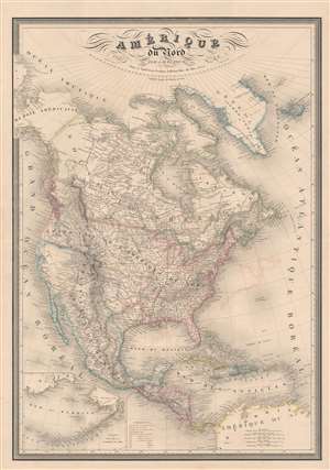
Amérique du Nord par A. H. Dufour...
sold
- Digital Map Information
- Suitable for large format printing
- Full resolution TIFF file
- ICC color profile embedded
- Delivered instantly via download link
A fine example of A.-H. Dufour's 1842 map of North America, including the Republic of Texas. The map covers the entire North American continent and Greenland, embracing Mexico, an independent Texas, Central America, and the Caribbean. An inset in the lower left corner details the Bering Sea and the Aleutian Islands. This map appeared in several editions of the Dufour/ Andriveau-Goujon elephant folio atlas, but this edition is significant for its inclusion of the Republic of Texas - and as such this makes it one of the earliest European maps to do so. The map also recognizes American claims to British Columbia - further underscoring the then hot political tensions between France and England. (more details)