
Floyd, Robert Wentworth (sold)

Robert Wentworth Floyd (August 12, 1879 - 19??) was a New York mapmaker of Quaker descent active in the middle part of the 20th century. Floyd was born in Boston, the son of Colonel Robert Mitchell Floyd (18?? - 1912). In 1898, he traveled to Nicaragua with a plan to become a coffee grower, but this apparently did not pan out, as he was in New York from about 1901. Maps of New York City, mostly intended for tourists, begin appearing under his name in copyright entries as early as 1933 and as late as 1940. Around 1939, his work was acquired by Andrew Gunnar Hagstrom, who began publishing under his own imprint, by 1940, Floyd had disappeared entirely.
Celebrates the 1933 opening of Rockefeller Center.
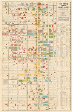
New York's Area of Greatest Interest.
sold
- Digital Map Information
- Suitable for large format printing
- Full resolution TIFF file
- ICC color profile embedded
- Delivered instantly via download link
This is a scarce 1933 first edition Robert Wentworth Floyd map of midtown Manhattan compiled for the Fifth Avenue Association and Rockefeller Center. Centered on Bryant Park, the map covers from 61st Street to 22nd Street and from 8th Avenue to Lexington Ave. Locations of note are color coded according to their function, with banks, churches, clubs, stores, hotels, office buildings, public buildings, railway terminals, and theaters differentiated. The verso contains text content promoting Rockefeller Center - which opened in the same year this map was published and most certainly contributed to its compilation. Also on the verso, there is a smaller map of New York City by Hagstrom illustrating transit routes. (more details)
Highlights Manhattan's many theatres, including the New Amsterdam and Lyric Theatres.
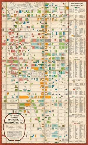
New York's Principal Theatre, Hotel, amd Shopping District.
sold
- Digital Map Information
- Suitable for large format printing
- File Size: 24.25 MB
- File Type: ZIP / TIFF
- ICC color profile embedded
- Delivered instantly via download link
This is a 1939 First Edition Hagstrom / R. W. Floyd map of Midtown Manhattan highlighting the Theatre District and its many theatres. The map depicts the city from Eighth Avenue to Lexington Avenue and from West 61st Street, Central Park, and East 61st Street to 22nd Street. Although numerous buildings are illustrated, not all the city blocks are filled. Banks, churches, clubs, department stores, hotels, nightclubs, office buildings, public buildings, train stations, and theatres are shaded using various colors to allow for easy differentiation and identification. An index, situated along the map's right side, lists the identified locations, offers a color-coding key, and notes each building's coordinates on the map. (more details)