
Foldex (sold)

Foldex (1934 - Present) was founded in 1934 by René Costard, trained as a violinist, who decided a change of direction was needed and founded his map business. Foldex created easy-folding maps, which led the company to immediate success and it took its place alongside Michelin as the most successful cartography companies in France. In 1970, the company changed its name to Recta Foldex after a restructuring. Following René’s death, his wife Simone Costard took over the business. In 1985 Simone Costard sold the business to the Swiss cartographer Kümmerly Frey. In 1993, the first Atlas of France in A4 format was published, and the Recta Foldex bought the company Éditions Blay. The two companies merged and became Blay-Foldex.
Incredible map with several advertisements geared toward cyclists!
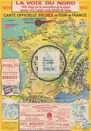
Carte Officielle FOLDEX du Tour de France.
sold
- Digital Map Information
- Suitable for large format printing
- File Size: 34.78 MB
- File Type: ZIP / TIFF
- ICC color profile embedded
- Delivered instantly via download link
This is a 1950 Foldex and La Voix du Nord route map of the Tour de France cycling race. The map depicts France and the surrounding countries from the Atlantic Ocean to Italy, Switzerland, and Belgium and from the English Channel to Spain and the Mediterranean Sea. ... (more details)