
Gallup Map and Supply Company (sold)

Gallup Map and Supply Company (1875 - present) is an American map company founded in Kansas City, Missouri in 1875. Originally, the Gallup Map Company created local street atlases and wall maps and, with the advent of cell phones and GPS, have transitioned into creating reproductions of historical and vintage maps.
Kansas City 'Nearest by Air to Everywhre.'
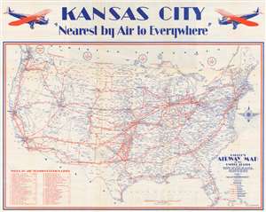
Gallup's Airway Map of the United States Showing Air Ports, Air Stations, Index to Air Trainsportation Lines and Airline Distances Between Air Stations.
sold
- Digital Map Information
- Suitable for large format printing
- File Size: 37.87 MB
- File Type: ZIP / TIFF
- ICC color profile embedded
- Delivered instantly via download link
This is a 1928 Gallup Map and Supply Company map of the United States promoting Kansas City as a hub of national aviation. Centered on Kansas City, 'Nearest by Air to Everywhere', the map covers the whole of the Untied States. Bold red lines highlight air transportation routes to and from Kansas City , with icons reminiscent of highway signs identifying which companies flew along each line. These icons correspond with an index situated in the lower left corner that lists forty-six different air transportation companies and informs the viewer whether the line operates passenger, mail, or express service, or some combination of the three. In some cases, multiple companies fly the same route, although many of the routes listed are operated by only one company. Air stations along the routes are marked by large circles and labeled. Airports are also marked by smaller red circles It is unclear, however, exactly what the distinction is between air stations and airports. (more details)