
Godwin, William Harrison (sold)

William Harrison Godwin (March 21, 1899 - January 11, 1984), who went by Harrison, was an American cartoonist, pictorial map artist, and hotelier active in California during the early to middle parts of the 20th century. Harrison was born in Hackettstown, New Jersey. Harrison was a cartoonist with the Los Angeles Examiner and published two daily strips. With regard to cartographic material he published just three maps, San Francisco, Hollywood, and North America, all between the years of 1927 and 1929. The San Francisco and Hollywood maps were the first and second maps in a planned series of American cities, each taking some three months to complete. Curiously, no further maps in the series materialized. In addition to his cartoon work Harrison, in partnership with his brother Fred, owned Carmel-by-the-Sea's La Playa Hotel, where Harrison worked as a manager. Later, in 1940, Harrison sold his interest in the La Playa and acquired full ownership of the Pine Inn, also in Carmel and still active. Harrison and Fred Godwin and are credited with popularizing Carmel as a tourist destination. Little else is known of his life.
Best and largest pictorial map of San Francisco.
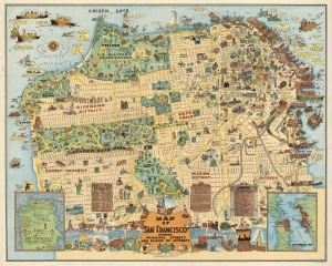
Map of San Francisco Showing Principal Streets and Places of Interest.
sold
- Digital Map Information
- Suitable for large format printing
- File Size: 48.96 MB
- File Type: ZIP / TIFF
- ICC color profile embedded
- Delivered instantly via download link
This is a 1927 Harrison Godwin pictorial map of San Francisco, California - considered the best genre illustration of that city. Comic illustrations appear alongside depictions of San Francisco landmarks, including the Fine Arts Palace, the Twin Peaks, and Fisherman's Wharf. Golden Gate Park appears in detail, with the many animal enclosures, lakes, and buildings all illustrated. The city's schools, churches, hospitals, post offices, and even the U.S. Mint (complete with workers shoveling gold coins into the back of a van) are marked. A surprising number of golfers and golf courses populate the map, with one fellow holding a sign that reads, 'San Francisco has 365 golfing days in the year'. Placards near the bottom border bear facts about the city and list its banks and theaters. Comic panels line the bottom border and present events in San Francisco's history, from its founding to its many fires. An inset in the lower left marks important events, while the inset in the lower right depicts the Greater Bay Area. (more details)
Best and largest pictorial map of San Francisco.
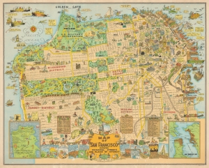
Map of San Francisco Showing Principal Streets and Places of Interest.
sold
- Digital Map Information
- Suitable for large format printing
- File Size: 61.66 MB
- File Type: ZIP / TIFF
- ICC color profile embedded
- Delivered instantly via download link
This is a 1927 Harrison Godwin pictorial map of San Francisco, California - considered the best genre illustration of that city. The map offers a wealth of unique detail that only a local would know - the balloon over the Presidio, a well-known homeless character in Richmond, criminal activity in Sutro Forest, and more. (more details)
Scarce promotional cartoon map illustrating the routes of the Panama Mail Steamship Company.
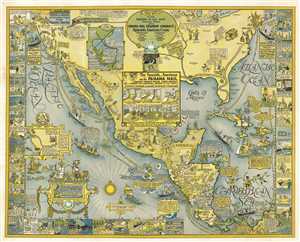
Panama Mail S.S. Co. The Sea Coastes of America shewing the Ports of call of the Panama Mail steamships as the Country there aboutes is lying and situated, with all the havens thereof. Exactly done and corrected with great diligence.
sold
- Digital Map Information
- Suitable for large format printing
- File Size: 51.39 MB
- File Type: ZIP / TIFF
- ICC color profile embedded
- Delivered instantly via download link
An extremely scarce 1928 pictorial map by Harrison Godwin promoting the routes of the Panama Mail Steam Ship Company. In Godwin's classic style, the map humorously covers North American from New York and San Francisco south to Columbia, including all of Central ... (more details)