
Goeree, Jan (sold)

Jan Goeree (1670 - 1731) was a Dutch painter, draughtsman and printmaker. He was also known as a poet. He was the son of one Willem Goeree and no details come down to us of his youth in Middleburg. In Amsterdam he was a pupil of Dutch Golden Age painter and art theorist Gerard de Lairesse. He lived out his life in Amsterdam, the city in which most of his work was produced. His engraving appeared in De Fer's Atlas Royal. Tooley's Dictionary is probably mistaken in saying he worked for Pieter van der Aa. Although his imprint is to be found on van der Aa's large format maps, these were executed on behalf of François Halma as early as 1694, and the plates later acquired and reprinted by van der Aa in 1713.
The Deluge Remakes the World.
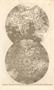
Den Aardkloot nade Zondvloed, in haar gebroken stand, met Bergen en dalen, groote Zee-Boesem, en der selver Eilanden en Ondiepten vertoond.
sold
- Digital Map Information
- Suitable for large format printing
- File Size: 5.08 MB
- File Type: ZIP / TIFF
- ICC color profile embedded
- Delivered instantly via download link
This is Thomas Burnet's curious c. 1694 map of the Earth's hemispheres, from the Dutch book Voor-Bereidselen Tot de Bybelsche Wysheid…. Meant to demonstrate Burnet's idiosyncratic cosmogony, it is notable for its mapping of California as an island and an interconnected Arctic-North American landmass, among other features. (more details)
Antediluvian Earth - science and theology.
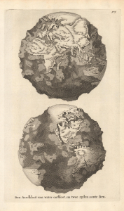
Den Aardkloot van water ontbloot, na twee zijden aante sien.
sold
- Digital Map Information
- Suitable for large format printing
- File Size: 4.67 MB
- File Type: ZIP / TIFF
- ICC color profile embedded
- Delivered instantly via download link
This is Thomas Burnet's curious c. 1694 depiction of the Earth's hemispheres, from the Dutch book Voor-Bereidselen Tot de Bybelsche Wysheid…. Meant to demonstrate Burnet's idiosyncratic cosmogony, this sheet reveals the state of natural philosophy at the time, just as the mapping of California as an island and other oddities reflect the ongoing development of geographical knowledge. (more details)
Baroque Masterpiece in the Mapping of Africa.
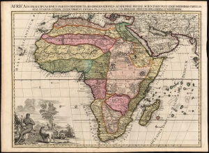
L'Afrique selon les nouvelles observations de Mssrs de l'Académie des sciences, etc., Africa in praecipuas ipsius partes distributa, ad observationes academiae regiae scientarum et exquisitissimas tabulas quae nunquam antehac lucen vederunt, Excusa A Francisco Halma, cum privilegio ordinum Hollandiae et westfrisiae.
sold
- Digital Map Information
- Suitable for large format printing
- Full resolution TIFF file
- ICC color profile embedded
- Delivered instantly via download link
This is the rare first state of François Halma's c. 1699 separately-issued map of Africa. Its unusually large folio size, bold and sophisticated engraving, and rich original color sets this map apart as one of the most beautiful obtainable late-17th century maps of the continent. (more details)