
Goulart, Jacques (sold)

Jacques Goulart (1580 - 1622) was a Swiss cartographer, whose map of Lake Geneva would provide the basis for the maps of that lake and its surrounds produced by Hondius, Blaeu and Jansson. It is tempting to surmise that he might be related to the French Reformed theologian Simon Goulart (1543 - 1628) but the genealogies of neither man are complete. We know nothing of his background, and his superb map of Lake Geneva appears to be his sole cartographic contribution. Some biographers also credit Jacques as a theologian, but we can find no published work by the man to support this.
Northern Savoy Just After France Captured It.
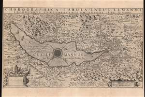
Chorographica Tabula Lacus Lemanni Locorumque Circumiacentium Auctore Iac. G. Genevensi.
sold
- Digital Map Information
- Suitable for large format printing
- DPI: 600
- File Size: 52.73 MB
- File Type: ZIP / TIFF
- ICC color profile embedded
- Delivered instantly via download link
An uncommon and beautiful map of Lake Geneva engraved by Jodocus Hondius for inclusion in his 1606 edition of the Mercator Atlas. This southeast-oriented map depicts the Canton of Geneva in detail and centers on Lake Geneva. The Rhone River can be seen flowing into the lake in the southeast and out again, through the city of Geneva in the west. It is a superb engraving, with elegant strapwork cartouches and dramatic, pictorially-represented mountains. The stippled Lake Geneva is graced with an elaborate compass rose, an array of ships, and even a handful of rowboats. Several geese menace the western coastline, while peeking from the water northwest of the compass rose is a remarkably understated sea monster. (more details)
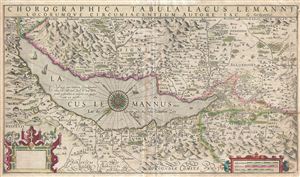
Chorographica Tabula Lacus Lemanni Locorumque Circumiacentium Auctore Iac. G. Genevensi
sold
- Digital Map Information
- Suitable for large format printing
- DPI: 300
- File Size: 12.49 MB
- File Type: ZIP / TIFF
- ICC color profile embedded
- Delivered instantly via download link
An uncommon and beautiful map of Lake Geneva engraved by Jodocus Hondius for inclusion in his 1606 edition of the Mercator Atlas. It is one of the best-detailed maps of the region based on firsthand report, derived from the manuscript map of native Jacques Goulart. (more details)