
Graves, Thomas (sold)

Thomas Graves (1802 - August 28, 1856) was a Northern Irish office in the Royal Navy and gentleman scholar. Graves was born in Belfast and joined the Royal navy in 1816. He was promoted to lieutenant in 1827 by Philip Parker King of the HMS Adventure, under whom he learnt surveying at the South America Station. He was promoted to Lieutenant-Commander in 1836, given command of the HMS Mastiff, and assigned to survey work in the Mediterranean. He was joined on this post to Thomas Abel Brimage Spratt (May 11, 1811 - March 12, 1888), with whom he mapped the Troada is stunning detail in search of the, then lost, city of Tory. In 1840 the Pair produced 'Spratt's Map,' as it came to be known, which led directly to Schliemann's discovery of Tory. Graves' next ship, from 1841, also in the Mediterranean, was as Commander of the HMS Beacon. With the Beacon, Graves was assigned to transport the Xanthian Obelisk from the Lycian coast to England. In 1846 he was assigned to command the HMS Ceylon, again in the Mediterranean. In 1853 he was made Superintendent of Ports at Malta. Graves died in Malta on August 28, 1856, from a wound inflicted by Maltese boatman Giuseppe Meli, who was later tried for Graves's murder.
Spratt's Map' that led directly to the rediscovery of the lost Homeric city of Troy!
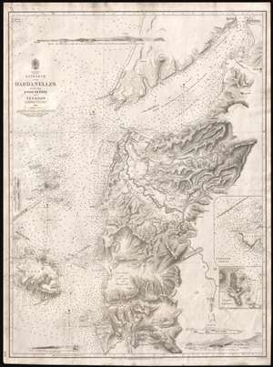
Asia Minor. Entrance of the Dardanelles, with the Plain of Troy and Tenedos.
sold
- Digital Map Information
- Suitable for large format printing
- DPI: 300
- File Size: 11.62 MB
- File Type: ZIP / TIFF
- ICC color profile embedded
- Delivered instantly via download link
Known as 'Spratt's Map', this is a most intriguing 1844 British Admiralty chart or map of the Entrance to the Dardanelles and the Troada or Plain of Troy. Compiled by Royal Navy officers Thomas Abel Brimage Spratt and Thomas Graves, this map played a significant role in the discovery of Tory. While this, like most early Admiralty charts can be admired for its supreme maritime detail and accuracy, the map's most intriguing quality is its extraordinary inland detail covering the eastern quarter of the Troada, including the Plain of Troy. Here, Graves and Spratt have left aside their usual nautical survey work to put the resources and training of the British Hydrographic Office to work on a far more important matter - the search for the ruins of lost Troy. (more details)