
Gray, Andrew Belcher (sold)

Andrew Belcher Gray (July 6, 1820–April 16, 1862) was an American surveyor active in the 20 years prior to the American Civil War. Gray was born in Norfolk Virginia. He studied surveying under Andrew Talcott and assisted him in 1839 surveying the Mississippi River Delta. He then joined the Republic of Texas Navy as a midshipman. He was assigned to survey the Texas –U.S. boundary under Memucan Hunt. Later, from 1844 – 1846 he led a team surveying the Keweenaw Peninsula in Michigan in search of mineral resources. Gray returned to Texas to take part in the Mexican-American War and after the war was assigned to the U.S.-Mexican Border Commission. After a dispute with is commander, John Bartlett, he was dismissed form the commission only to be replaced by his friend, William Emory. Although Emory's name is on the work, Gray surveyed much of the border from the Rio Grande, over the Black Range, down the Gila River to its junction with the Colorado River, and across the desert of southern California to the Pacific Ocean at San Diego. Having accompanied the border commission as far as San Diego Bay, Gray took part in the founding of modern San Diego, California. In 1852 he took work with the Texas Western Railroad and surveyed tracks from San Antonio towards the Colorado River. With the outbreak of the American Civil War, Gray joined the Confederate Army and worked as an engineer fortifying the Mississippi River. He died in 1862 1862 when the boiler of a steamboat he was traveling on exploded. He was survived by a wife and three daughters.
Scarce map illustrating original survey work of the Mineral Districts around Lake Superior.
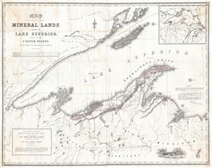
Map of that Part of the Mineral Lands adjacent to Lake Superior, ceded to the United States by the Treaty of 1842 with the Chippewas. Comprising that District lying between Chocolate River and Fond du Lac, under the superintendency of Genl. John Stockton, U.S. Agent.
sold
- Digital Map Information
- Suitable for large format printing
- File Size: 81.8 MB
- File Type: ZIP / TIFF
- ICC color profile embedded
- Delivered instantly via download link
A rarely seen and massive 1845 government issued map of the western part of Lake Superior drawn to illustrate mining districts. The map covers from Cass Bay and Grand Island westward as far as the American Fur Company Depot at the mouth of the River St. Louis, or ... (more details)