
Haas, Philip (sold)

Philip Haas (1808 - c. 186?) was a German-American daguerreotypist and lithographer active in the mid-19th century. Haas was born in Germany but emigrated to the United States in 1834, rapidly establishing himself as a lithographer and printer in Washington D. C. Between 1834 and 1840 he received several government printing contracts from the U.S. Navy and other offices. Around 1840 he may have traveled to Paris to study the newly invented daguerreotype photo system. His earliest known daguerreotype is dated March of 1843. With his 1843 portrait of president John Quincy Adams, Haas is credited with being the first to transfer a daguerreotype directly to lithographic stone. He relocated to New York City in 1944, opening a daguerreotype gallery on Broadway, which he ran to about 1860. In 1860, at the outbreak of the American Civil War, Haas enlisted with First New York Engineers and was sent to South Carolina. He may have lied about his age, as he was 53 at the time, too old for enlisted service. Taking advantage of his daguerreotyping skills, Haas, produced several important photographs, including images of the U.S.S. New Ironsides in action. Poor health and an end to the war led him to retired on May 25, 1863. The date of his death is unknown.
Fortifying the western frontier.
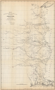
Map Illustrating the plan of the defences of the Western Frontier, as proposed by Maj. Gen. Gaines, in his plan dated Feby. 28th 1838.
sold
- Digital Map Information
- Suitable for large format printing
- File Size: 13.99 MB
- File Type: ZIP / TIFF
- ICC color profile embedded
- Delivered instantly via download link
This is an 1838 David Burr map of part of the central United States created to illustrate Major General Edmund P. Gaines' plan to protect the United States' Western border. The map reflects the tenuous political situation in North America after the 1803 Louisiana Purchase but before the Mexican-American War (1846 - 1848). American Indians and Mexican expansion were seen as the primary threats to U.S. sovereignty, and a secure border was considered essential to westward expansion. (more details)
The finest 19th century chart of Cape Fear and Bald Head Island!
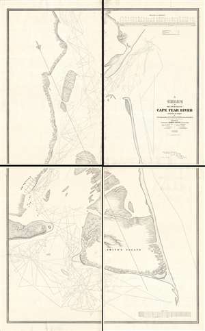
A Chart of the Entrance of Cape Fear River.
sold
- Digital Map Information
- Suitable for large format printing
- DPI: 300
- File Size: 52.16 MB
- File Type: ZIP / TIFF
- ICC color profile embedded
- Delivered instantly via download link
Without a doubt, this 1839 wall-map sized chart by James Glynn is the finest map of Cape Fear and vicinity to appear in the 19th century. Although much changed from repeat storms, this 1839 chart covers roughly from Kure Beach and Fort Fish Historic Site to the southern part of Bald Head Island (Smith Island) and from Southport (Smithville) to the Atlantic. The map exhibits a wealth of detailed soundings as well as some landside information including the course of rivers and streams, the positions of the Federal Point and Cape Fear lighthouse, and the street grid of Smithville / Southport. (more details)