
Hall, Harrison (November 5, 1785 - March 9, 1866) (sold)

Rare first Harrison edition of De Berniere's map of the Battle of Bunker Hill.
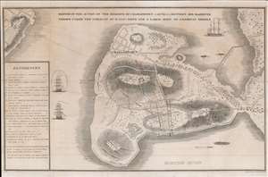
Sketch of the Action on the Heights of Charlestown 17 June 1775 Between His Majesty's Troops Under the Command of M. Genl. Howe and a Large Body of American Rebels.
sold
- Digital Map Information
- Suitable for large format printing
- DPI: 600
- File Size: 14.83 MB
- File Type: ZIP / TIFF
- ICC color profile embedded
- Delivered instantly via download link
This is a rare 1818 map of the 1775 American Revolutionary War Battle of Bunker's Hill, Boston. Cartographically, the map is derived from a sketch by Henry De Berniere, a reconnaissance Ensign (spy) under British commanding General Thomas Gage. The original manuscript, from all reports, was discovered in a trunk in the early 19th century. De Berniere witnessed Bunkers Hill first-hand and prepared the map for his report to Gage. The map is distinctive for its exacting attention to detail and topography, including the layout of Charlestown, as well as its overall fine execution, illustrating all troop movements, underscoring's De Berniere's officer's education as a military engineer and draftsman. When the map was discovered in an old trunk, it was instantly recognized as the finest record of the battle available and became the model for most subsequent illustrations of the events. (more details)