
Hejian Prefecture Catholic Church (sold) (河間府天主堂)

Hejian Prefecture Catholic Church (河間府天主堂; fl. c. 1875 - 1925) The Apostolic Vicariate of Southeast Zhili (直隸東南代牧區) was established in 1856 in the flurry of missionary activity accompanying the official toleration of Christianity after the First Opium War. Like many missions in China at the time, the Hejian Church had a printing press and published a variety of devotional, literary, and scientific materials.
AKA: 河間府天主堂
Chinese-Jesuit Map published at the Heijian Mission.
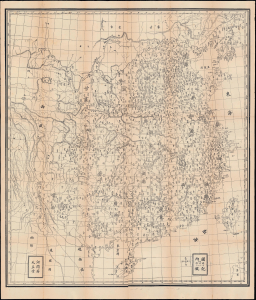
[China].
sold
- Digital Map Information
- Suitable for large format printing
- File Size: 73.39 MB
- File Type: ZIP / TIFF
- ICC color profile embedded
- Delivered instantly via download link
Of this utmost rarity, this is a highly detailed c. 1880 Chinese map of China produced by the Hejian Prefecture Catholic Church of the Jesuit mission in Southeastern Zhili. The map is significant for its combination of Western and Chinese mapping styles. The map is overlaid with a grid representing latitude and longitude, with a line running through Beijing serving as the prime meridian. It also incorporates an interesting method of scaling, with each square in the grid representing an area that is 250 li across and 350 li tall (one li was equivalent to between 537 and 645 meters during the Qing period). (more details)