
Hoffman, Abraham J. (sold)

Abraham J. Hoffman (1834 - 18??) was a draughtsman, engraver, lithographer, and engineer active in Albany New York. Hoffman was born in Albany, New York. He may have been the son of L. G. Hoffman, who published Hoffman's Albany Directory in the 1840s. He mastered lithography and engraving in Albany and established himself as Hoffman and Company, possibly with Richard H. Pease. In 1853 he is listed as an Albany wood engraver and his offices were destroyed by fire. From 1856 to 1862 he was part of Hoffman, Knickerbocker and Co. The partnership dissolved and Hoffman moved to Chicago in 1863, possibly following a relative, where he produced lithographs for the drugs store Hoffman Brothers. In 1865 he became the 'and co.' in the Baker and Company lithography and engraving firm. He left the firm a year later to invest in real estate, relocating to River Forest in 1869. He must have done well in real estate as he founded the River Forest Young Ladies Seminary in 1874, which was run by his wife until about 1884.
Who owns New York City? City or State?
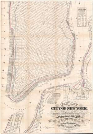
New Map of that Part of the City of New York south from 20th Street on the Hudson and 35th Street on the East River.
sold
- Digital Map Information
- Suitable for large format printing
- File Size: 45.27 MB
- File Type: ZIP / TIFF
- ICC color profile embedded
- Delivered instantly via download link
This is a rare map drawn to settle a land rights dispute between New York City and New York State. The map extends from roughly 32nd street to the Battery and includes the shorelines of Brooklyn and Queens. It illustrates the city's street grid, showing all piers and docks, ferry lines, and the pier line. Most importantly, it illustrates the cities original boundary line, noting both the high and low water marks (this was one of the maps consulted by Egbert Viele to produce the famous 1865 Waterways Map). More importantly, it illustrates the shore boundaries of Manhattan and Brooklyn according to the various surveys and charters completed between 1735 and 1808. (more details)