
Huang Qianren (sold)

Qianren Huang (黃千人, 1694 – 1771) was a Chinese cartographer active 18th century during the reign of the Qianlong Emperor. He was born in Yuyao, Zhejiang, China. He passed the state civil service exam for Tai-an and was awarded a position as a clerk. His grandfather was the great Qing Chinese polymath and 'Father of the Chinese Enlightenment' Huang Zongxi (黄宗羲) (1610-1695), father of Huang Baijia (黃百家) (1643-1709). He is best known for his 1767 revision of Huang Zongzi's map 天下舆图, published as DaQing Wannian Yitong Tianxia Quantu (大清万年一统天下全图)or All-Under-Heaven Complete Map of the Everlasting Unified Qing Empire.
A cartographic expression of the Qing tribute system, this is the earliest known printed example of the 'Tianxia Quantu' map of Qing China.
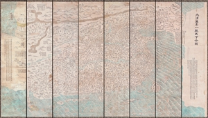
DaQing Wannian Yitong Tianxia Quantu / 大清万年一统天下全图 / All-Under-Heaven Complete Map of the Everlasting Unified Qing Empire
sold
- Digital Map Information
- Suitable for large format printing
- File Size: 89.96 MB
- File Type: ZIP / TIFF
- ICC color profile embedded
- Delivered instantly via download link
A seminal 1806 (Jiaqing 11) Qing Dynasty Chinese map of utmost importance and rarity, this is the earliest known printing of Huang Qianren's (黃千人, 1694–1771) grand and spacious map of the Great Qing Empire of China. Huang Qianren first drew this map ... (more details)
The Blue Map of China - one of the most important and beautiful maps ever made.
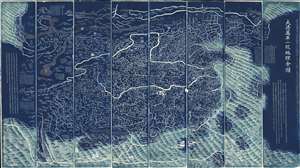
DaQing Wannian Yitong Tianxia Quantu / 大清万年一统天下全图 / All-Under-Heaven Complete Map of the Everlasting Unified Qing Empire
sold
- Digital Map Information
- Suitable for large format printing
- Full resolution TIFF file
- ICC color profile embedded
- Delivered instantly via download link
The legendary Blue Map of China under the Great Qing, one of the rarest, largest, and most aesthetically magnificent Chinese maps ever made. Published in 1811 (Jiaqing 16) in the Qing Dynasty, this Chinese map by Huang Qianren (黃千人, 1694–1771) is of utmost significance. Although ostensibly a map of China, the coverage of this map in fact extends to all lands touched by the influence Qing Empire, including England, Holland, Southeast Asia, Arabia, and Africa. As such it can be considered a political manifesto lionizing the unity and majesty of Qing China as well as a functional administrative document. (more details)
Ceremonial and Administrative Embodiment of the Qing.
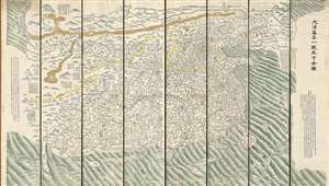
DaQing Wannian Yitong Tianxia Quantu / 大清万年一统天下全图 / All-Under-Heaven Complete Map of the Everlasting Unified Qing Empire
sold
- Digital Map Information
- Suitable for large format printing
- Full resolution TIFF file
- ICC color profile embedded
- Delivered instantly via download link
A seminal 1821 (Daoguang 1) Qing Dynasty Chinese map of utmost importance and rarity, this is Huang Qianren's (黃千人, 1694–1771) grand and spacious map of the Great Qing Empire of China. Although ostensibly a map of China, the coverage of this map in fact extends to all lands touched by the influence Qing Empire, including England, Holland, Southeast Asia, and Africa. As such it can be considered a political manifesto lionizing the unity and majesty of Qing China as well as a functional administrative document. This edition of the map, 1821, was issued to memorialize the reign of the Jiaqing Emperor and celebrate the coming Daoguang reign. (more details)