
Huang Shang (sold)

Huang Shang (黃裳; 1146 - 1195) was a Chinese official, tutor, polymath, and cartographer of the Southern Song Dynasty. He is known for at least three maps, the Dili Tu (墬理圖) terrestrial map, the Tianwen tu (天文圖) star chart, and a third relief map now lost, and it is believed that he made at least five others. Huang was born in Longqing Prefecture (隆慶府) now part of Zitong County in Sichuan Province. He passed the jinshi level of the imperial exams in the 5th year of the Xiaozong Emperor's reign (1167 CE) and became a county official in Bazhou (巴州) in Sichuan. He graduated from the Taixue Imperial Academy (in Hangzhou at this time) and held several official positions in the following decades, including as a tutor to 'Prince Jia' (that is, Zhao Kuo 趙擴, the future Ningzong Emperor), in 1190. He presented eight maps in total to the prince, including a map of China carved in wood - the Dili Tu. Huang intended for the Dili Tu to teach the value and importance of reuniting the empire which was split between the northern Chinese Jin Dynasty and the Southern Song sixty years earlier. Huang held high-level positions in the late Xiaozong era and during the brief reign of the Guangzong Emperor (r. 1189 - 1194), including Imperial Household Secretary (起居舍人), Head of the Imperial Secretariat (中書舍人), and Imperial Secretary (給事中). Being a close advisor of Zhao Kuo, he advanced even further when Zhao became the Ningzong Emperor, becoming Imperial Tutor (侍讀) and Minister of Rites (禮部尚書), arguably the most important position in the imperial bureaucracy. Aside from maps, Huang wrote several works that fit well within the Neo-Confucian ideology that had become dominant at the time, heavily citing classical texts and doctrines.
黄裳(1146 - 1195),南宋官员、学者、导师、博学之士与制图家。以至少三幅地图闻名,包括《墬理图》陆地地图、《天文图》星图,以及一幅已佚失的地形图,另推测他还制作过至少五幅其他地图。黄裳生于隆庆府(今四川梓潼县),孝宗五年(1167年)中进士,初任四川巴州县官。后卒业于太学(时在杭州),在数十年间历任多职,包括1190年任嘉王(即赵扩,后来的宁宗皇帝)之师。其间曾向太子献八幅地图,其中包括木刻版《墬理图》,旨在阐明统一帝国的重要性——六十年前帝国已被金朝与南宋分裂。黄裳在孝宗末及光宗(1189—1194年)朝任起居舍人、中书舍人、给事中等高位。赵扩即位后,因关系亲近而晋为侍读、礼部尚书,此为当时最重要的官职之一。除地图外,黄裳亦著有多部作品,契合当时占主导的新儒学思想,广引经典与义理。
黄裳(1146 - 1195),南宋官员、学者、导师、博学之士与制图家。以至少三幅地图闻名,包括《墬理图》陆地地图、《天文图》星图,以及一幅已佚失的地形图,另推测他还制作过至少五幅其他地图。黄裳生于隆庆府(今四川梓潼县),孝宗五年(1167年)中进士,初任四川巴州县官。后卒业于太学(时在杭州),在数十年间历任多职,包括1190年任嘉王(即赵扩,后来的宁宗皇帝)之师。其间曾向太子献八幅地图,其中包括木刻版《墬理图》,旨在阐明统一帝国的重要性——六十年前帝国已被金朝与南宋分裂。黄裳在孝宗末及光宗(1189—1194年)朝任起居舍人、中书舍人、给事中等高位。赵扩即位后,因关系亲近而晋为侍读、礼部尚书,此为当时最重要的官职之一。除地图外,黄裳亦著有多部作品,契合当时占主导的新儒学思想,广引经典与义理。
Oldest surviving rubbing of the Dili Tu. /《墬理图》现存最古老碑拓
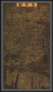
Dili tu. / 墬理圖
sold
- Digital Map Information
- Suitable for large format printing
- File Size: 57.31 MB
- File Type: ZIP / TIFF
- ICC color profile embedded
- Delivered instantly via download link
An outstanding discovery, this is the legendary c. 1247 Dili tu (墬理圖) terrestrial map of China. This is the earliest surviving example of one of the earliest known maps of China produced in the Common Era. The map was drawn by the Chinese polymath Huang Shang (黃裳). Huang's original wood carving, produced around 1194, has long been lost, but the map was engraved in stone in 1247 by Wang Zhiyuan (王致遠). This rubbing comes from that stone and dates to sometime between 1493 and 1602 - making it the oldest known extent rubbing of the Dili tu of China. The present map has been carbon-dated as having been created between 1493 and 1602, with supplementary ink testing verifying the results (these documents are available upon request and accompany the item). (more details)