
Hunter Thomas (sold)

Thomas Hunter (c. 1827 - December 24, 1898) was an Irish-American lithographer active in Philadelphia from around 1868 until at least 1894. Born in Ireland, Hunter immigrated to the United States in 1831 and lived in Philadelphia with his parents and American-born siblings. He appears as a printer in the 1860 census and was working with Stephen C. Duval, son of P.S. Duval, in the firm Duval and Hunter by 1868 or 1869. The firm's reputation grew in prestige. Hunter assumed sole ownership of the lithographic firm in 1874 and in 1876 was named one of the Philadelphia publishers authorized to publish views the 1876 Centennial Exhibition. Over the course of the late 1870s and the early 1880s, Hunter's firm began to accrue incredible amounts of debt. Hunter turned over management of the firm to William H. Butler at some point in the early 1880s, and in January 1886, the establishment suffered a business-ending fire. By that point, Butler had paid off nearly 2/3 of the remaining debt. It is unclear if Thomas Hunter died on December 24, 1898 or not. We have found a death certificate with this date and a correspondingly close birth date in Ancestry.com records, but there is also an entry in the 1900 Census for a Thomas Hunter who was born in Ireland and living as an inmate in an almshouse.
Celebrates the centennial of the signing of the Declaration of Independence.
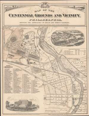
Map of the Centennial Grounds and Vicinity, Philadelphia. Showing the Approaches by Steam and Street Railways.
sold
- Digital Map Information
- Suitable for large format printing
- Full resolution TIFF file
- ICC color profile embedded
- Delivered instantly via download link
This is an 1875 Samuel Crawford Smith map of the Centennial Exhibition in Philadelphia, Pennsylvania. The Exhibition's main buildings, the Main Exhibition Building, the Machinery Building, Horticultural Hall, the Art Gallery, and the Agricultural Building, are all illustrated and labeled. One hundred thirty-five other buildings across the fairgrounds are numerically labeled and correspond with an index situated in the lower left. Pathways through the fairgrounds are illustrated, some named, including Belmont Avenue, Fountain Avenue, and River Road. Downtown Philadelphia occupies the lower right, with its street grid clearly illustrated. Numerous railroads, such as the Pennsylvania Railroad, traverse the city and serve the fairgrounds. The Schuylkill River cuts a diagonal path through the city and creates the fair's eastern border. A steamboat landing was explicitly built for the Exhibition and directly connected the river and the fairgrounds. (more details)