
Imbert, J. Leopold (sold)

J. Leopold Imbert (fl. c. 1777 - 1778) was a French mapmaker active in Paris during the 1770s. We have been able to isolate no substantial information on Imbert and he appears to have produced a single map, the important Carte Des Possessions Angloises Dans l'Amerique Septentrionale.
Important map of the British Colonies in North America at the outset of the American Revolutionary War.
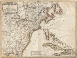
Carte des Possessions Angloises Dans L'Amerique Septentrional Pour Servir d'Intelligence á la Guerre presente Traduite de L'Anglois Par J. Leopold Imbert.
sold
- Digital Map Information
- Suitable for large format printing
- DPI: 300
- File Size: 15.9 MB
- File Type: ZIP / TIFF
- ICC color profile embedded
- Delivered instantly via download link
This is the rare 1777 separate issue, old color, first edition of J. Leopold Imbert's important map illustrating the theater of the American Revolutionary War (1775 - 1783). In addition to being a significant map in its own right, this Imbert map underlies its own ... (more details)