
Jaillot, Bernard Antoine (sold)

Bernard-Antoine Jaillot (???? – 1749) was a French map publisher active in Paris in the first half of the 18th century. He is part of the prestigious Jaillot cartographic dynasty, his father is Bernard-Jean-Hyacinthe Jaillot (1673 - 1739), and grandfather Alexis-Hubert Jaillot (c. 1632- 1712). As both father and son published as 'B. Jaillot' or 'Bernard Jaillot', and both worked in the same style from the same offices on a Quai d'Augustins, they are often conflated and their separate work can be distinguished only by date and other tangential data. Like his father, Bernard-Antoine also held the position of Géographe Ordinaire du Roi. BnF data suggests he was born in the 18th century, but it is unlikely, has there are major publications positively attributed from 1717, which would be unlikely.
Lost treasure of Parisian Cartography.
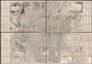
Plan de la Ville de Paris et de ses Faubourgs dédié au Roi.
sold
- Digital Map Information
- Suitable for large format printing
- Full resolution TIFF file
- ICC color profile embedded
- Delivered instantly via download link
The only known example, in this edition, of Bernard-Antoine Jaillot's 1748/1767 large-scale map of Paris. The map is centered on the Île de la Cité and is oriented to the southeast, with the Seine running vertically through the center of the map - a convention established in 1713 by the author's father Bernard-Jean-Hyacinthe Jaillot and followed in 1736-8 by Louis Bretez, and again, here. Coverage extends from the Faubourg Saint-Antoine to the Île des Cygnes that (attached to the Champ de Mars in the late 18th century), and from the Faubourg de Glories to the modern-day 14th arrondissement. Elaborate allegorical cartouches by Pierre-Alexandre Aveline appear in the upper left and right and feature titling and a legend, respectively. In the lower-left and right, inset maps detail the environs of Paris and France in general. The main map is flanked on either side by an exhaustive index of streets and important civic, military, government, mercantile, and ecclesiastical centers. (more details)