
Jaques, Herbert (sold)

Herbert Jaques (January 23, 1857 - December 21, 1916) was an American draftsman and cartographer. Born in Framingham, Massachusetts, Jaques studied at MIT. After graduating, he found a job as a draftsman in the offices of Henry Hobson Richardson. Jaques joined forces with another draftsman employed by Richardson, Robert Day Andrews, to create the firm Andrews and Jaques. In 1889, Augustus Neal Rantoul joined the firm, which was renamed Andrews, Jaques, and Rantoul. Andrews, Jaques, and Rantoul designed private residences, but their best known work are public and commercial buildings they designed for clients throughout the United States. Jaques married Harriet Sayles Francis on April 26, 1883.
The last edition of a landmark map in the cartography of Mount Desert Island.
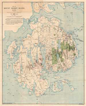
Map of Mount Desert Island Maine.
sold
- Digital Map Information
- Suitable for large format printing
- File Size: 19.96 MB
- File Type: ZIP / TIFF
- ICC color profile embedded
- Delivered instantly via download link
This is a 1911 map of Mount Desert Island, Maine compiled by Waldron Bates, Edward L. Rand, and Herbert Jaques. The map depicts the island from Blue Hill Bay to Frenchman's Bay and from Lamoine, Hancock, and Sorrento to Great Gott Island. Highly detailed, locations throughout the island are labeled, including the towns of Bar Harbor (labeled here as Eden), Mount Desert, Southwest Harbor, and Tremont. Villages throughout each of these towns are also labeled, including Salisbury Cove, Somesville, West Tremont, and Seal Harbor. The topography, illustrating elevation changes in forty-foot intervals, was adapted from the Map of Mount Desert Island issued by the United States Coast and Geodetic Survey in 1882, as was the hydrography.
(more details)
(more details)