
Jefferson, Peter (sold)

Peter Jefferson (February 29, 1708 - August 17, 1757) was a planter, cartographer and politician best known as the father of US President Thomas Jefferson (1743–1826). In collaboration with surveyor Joshua Fry, he produced in 1751 the so-called 'Fry-Jefferson Map'. Jefferson was born in the Virginia Colony at Osbornes on the James River, the son of a large property owner. He received no formal education in his youth, but was a well-read autodidact. He inherited land, becoming a prosperous plantation owner, slave owner, sheriff, surveyor and justice of the peace. He was also a surveyor and mapmaker: in 1749 he collaborated with Joshua Fry in the production of their 1751 A Map of the most Inhabited part of Virginia containing the whole Province of Maryland, which accurately depicted the Allegheny Mountains for the first time and showed the route of what would later be known as the Great Wagon Road.
Best colonial map of Virginia and Maryland.
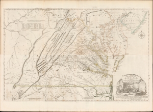
A Map of the most Inhabited part of Virginia containing the whole Province of Maryland with Part of Pensilvania, New Jersey and North Carolina drawn by Joshua Fry and Peter Jefferson in 1775.
sold
- Digital Map Information
- Suitable for large format printing
- Full resolution TIFF file
- ICC color profile embedded
- Delivered instantly via download link
This is the monumental 1775 Fry/Jefferson map of Virginia and Maryland, the most important colonial map of Virginia, in its original four-sheet English version. Drawn by Joshua Fry and Peter Jefferson in 1751 and first printed in 1753, this was the first accurate survey of the interior of Virginia. It was the first printed map to approximate the parallel ridges and valleys of the Appalachian Mountains, and the first to accurately depict the Blue Ridge Mountains. Following the revision of the map in 1755, this was the first map to include Virginia's road system, also marking routes used by frontier traders and Native Americans. Following that revision, it contained the best mapping of the Upper Ohio Valley and the Virginia frontier produced during the French and Indian War (1754 - 1763) and remained the prototype for all subsequent maps of Virginia until the 19th century. As both Fry and Jefferson were denizens of the colony, this further represents the first map of Virginia produced by Virginians. (more details)