
Kanakanui, Samuel Maikaaloa (sold)

Samuel Maikaaloa Kanakanui (November 4, 1864 - January 10, 1921) was a Hawaiian surveyor and map maker. Born in North Kohala, Hawaii, Kanakanui worked for the Hawaiian Government Survey and the Hawaiian Territorial Survey.
Most sophisticated 19th century map of Molokai.
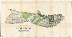
Hawaiian Government Survey. Molokai.
sold
- Digital Map Information
- Suitable for large format printing
- File Size: 154.9 MB
- File Type: ZIP / TIFF
- ICC color profile embedded
- Delivered instantly via download link
This 1897 Christopher Willis map of Molokai is the most sophisticated 19th century mapping of the island. Surveyors from the Hawaiian Government Survey mapped the length and breadth of Molokai and, per Moffat and Fitzpatrick, the map 'represents the final stage in the process of understanding and correctly illustrating the shape of this elongated island between O'ahu and Maui'. (more details)