
Kawamura Ryūjitsu (sold) (河村隆實)

Kawamura Ryūjitsu (河村隆實; fl. c. 1886 - 1894) was a Tokyo-based publisher of maps as well as books about cartography and geography.
Kawamura Ryūjitsu (sold) is also known as: 河村隆實
A huge map of Tokyo, to match the city's ambitions.
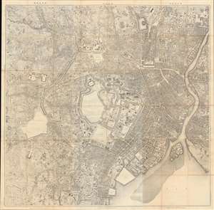
東京 / [Tokyo].
sold
- Digital Map Information
- Suitable for large format printing
- File Size: 253.96 MB
- File Type: ZIP / TIFF
- ICC color profile embedded
- Delivered instantly via download link
This enormous meticulously detailed 1894 (Meiji 27) Japanese Imperial Land Survey map of Tokyo is among the first truly modern maps of the city - the result of a monumental survey effort in the Early Meiji - and captures the city on the cusp of its transformation into a modern world capital. It is oriented to the north with the Imperial Palace at center and presents the city during a transformation from the old Tokugawa capital of Edo to the modernized capital of Imperial Japan. Given the size of this map and its production by the Imperial Land Survey, it very likely was used in a government office dealing with urban planning. (more details)