
Daniel J. Kenny (sold)

Daniel J. Kenny (fl. c. 1875 - 1900) was a Cincinnati-based cartographer and illustrator who made maps, guides, and pictorial handbooks of his home city.
Fifty locations around Cincinnati.
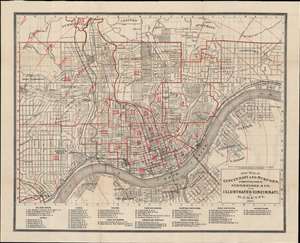
New Map of Cincinnati and Suburbs.
sold
- Digital Map Information
- Suitable for large format printing
- File Size: 19.02 MB
- File Type: ZIP / TIFF
- ICC color profile embedded
- Delivered instantly via download link
This is an 1875 D.J. Kenny map of Cincinnati, Ohio, and its suburbs. The map is oriented to the north, with the Ohio River dominating the lower portion of the map, acting as the border between Ohio and Kentucky. The map is detailed, labeling streets, utilities, railroads, and other parts of the city. At the bottom of the map, a list of 55 points of interest is included. Among the listed locations are railroad depots, hotels, theaters, parks, gardens, libraries, hospitals, public and private institutions, as well as charities. A pattern of half-mile concentric circles centered on downtown Cincinnati is overlaid onto the map. The city wards are also numbered. (more details)