
Laing, Joseph P. (sold)

Joseph P. Laing (1828 - 1905) was a Scottish printer and engraver active in New York during the middle part of the 20th century. Laing was born in Edinburgh, Scotland, and apprenticed as an engraver under W. H. Lizars. He emigrated to the United States in 1845, taking work with the firm of Snyder and Black. Afterwards, in 1850, Laing established himself as a private engraver and publisher at 25 Fulton Street. He also became a naturalized U.S. Citizen in 1852. In 1861, at the outbreak of the American Civil War he enlisted as a Captain in the Union Army, 79th Regiment, Scotch Highlanders. During his service, he was wounded eight times and captured (and escaped) twice. He fought at the Battle of Bull Run. Sometime during the war, he partnered with William Lang, and relocated his shop to 117 Fulton Street, which also, during this period, served as a Union Army recruiting office. Laing's partnership with Lang dissolved in 1862 but he continued to print under his own imprint until at least 1889. He was also a Mason of the Scottish Rite, a Major of the New York State National Guard, and was active with the Burns Club.
The best map of the Union Square area published in the 19th century.
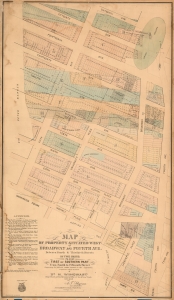
Map of Property Situated West of Broadway and Fourth Ave. Between Fourth and Thitieth Streets in Two Parts. / First or Southern Part From Fourth to Fifteenth Street.
sold
- Digital Map Information
- Suitable for large format printing
- File Size: 54.06 MB
- File Type: ZIP / TIFF
- ICC color profile embedded
- Delivered instantly via download link
A scarce c. 1875 Heinrich Windwart cadastral map of parts of Union Square and Greenwich Village, New York City. This map was issued to facilitate and profit on the implementation of the 1811 Commissioner's Plan and lotting of old New York estates. It is one of the earliest large-scale maps to specifically illustrate the Union Square area. (more details)