
Linschoten, Jan Huyghen van (sold)
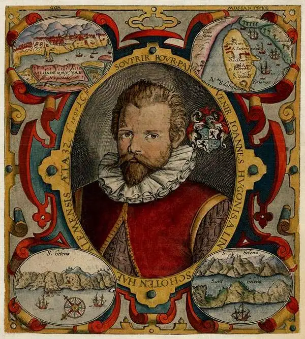
Jan Huyghen van Linschoten (1563 - February 8, 1611) was a Dutch merchant, cartographer, and historian active in the late 16th century. He was born in Haarlem, the son of a public notary but moved to Enkhuizen shortly thereafter. In 1576, at 14, Linschouten relocated to Spain, to apprentice as a merchant under this older brother, Willem van Linschouten, then active in Seville. He remained until 1580, when he took work in Lisbon, Portugal, under another merchant. He was in this position only briefly before Willem introduced him to the Archbishop of Portuguese Goa, Dominican Vicente da Fonseca, to whom he was appointed secretary. Accompanying Vicente da Fonseca, Linschoten arrived in Goa in September of 1583. He remained under Vicente da Fonseca for the next four years, often traveling with the Archbishop to far of locations such as China and Japan. During that time, he became fascinated with Asian cultures and their interaction with Europeans. With access at the highest level, he copied numerous maps and other documents, as well as records on sea routes to and from Goa, and trade agreements. When Vicente da Fonseca died in 1587, Jan Huyghen boarded a ship back to Holland, but was waylaid en route by a pirate attack and shipwreck in the Azores, where he remained until 1592. Back in Holland, Jan Huyghen joined the 1594 expedition of Willem Barentsz to the Kara Sea, north of Russia, in search of the fabled Northeast Passage to Asia. The Barentsz expedition was a failure, but Jan Huyghen survived and back in Holland with the support of Cornelius Claesz, he published an account the voyage. He also published a journal of his travels in Asia, in the process revealing a wealth of Portuguese trade secrets which ultimately influenced Dutch and English attempts to take over the East Asia trade. Among these he revealed was the ‘key’ to unlocking the Portuguese grip on passage through the Malacca Strait. He suggested traders approach the East Indies through the Sunda Strait, thereby circumventing Portuguese patrols in Malacca. This passage eventually became the main VOC thoroughfare into Southeast Asia and led to the Dutch colonization of the East Indies. In 1595 he married Reynu Meynertsdr Seymens, also of Enkhuizen. He remained with his family in Linschoten died in Enkhuizen, where he had worked as town treasurer until his death in 1611.
The Heart of Portuguese Power in the East.
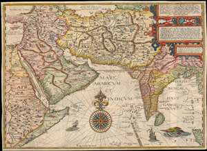
Deliniantur in hac tabula, Orae maritimae Abexiae, freti Mecani. al. Marís Rubri, Arabiae, Ormi, Persiae...
sold
- Digital Map Information
- Suitable for large format printing
- DPI: 600
- File Size: 59.14 MB
- File Type: ZIP / TIFF
- ICC color profile embedded
- Delivered instantly via download link
This is Jan van Linschoten's seminal 1596 map of the lands abutting the Indian Ocean, with coverage extending from the Arabian Peninsula to Sumatra. This map represents a significant advancement in accuracy and detail over any prior printed map of the region, setting the standard for most subsequent maps of the near east and south Asia for the remainder of the 16th and throughout the 17th century. Moreover, it exposed preciously guarded secrets of Portuguese maritime geography, paving the way for the Dutch seizure of the East India trade, thus spurring the Dutch Golden Age. (more details)
Earliest View of a strategic waypoint on maritime routes to the Far East.
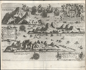
Vera effigies et delineatio insulae. Ascenscio nuncupatae... Waerachtighe affbeeldinghe en verthooninghe vant eylant Asçençion...
sold
- Digital Map Information
- Suitable for large format printing
- Full resolution TIFF file
- ICC color profile embedded
- Delivered instantly via download link
This is Jan van Linschoten's 1596 view of Ascension Island - considered the earliest printed depiction of Ascension Island in the South Atlantic. This view derives from Linschoten's firsthand observation: his narrative of his return to Europe from India describes the approach to the island, sailing northwest from the Cape of Good Hope, the abundance of the island's fish (including flying fish smacking into the ships), and the fleet's continued journey to Cape Verde and the Canaries. (more details)