
Longchamps, Sebastian G. (sold) (Sébastian G. Longchamps, Sébastien Longchamp)

Sebastian G. Longchamps (1718 - 1793) was a French geographer and map publisher active in Paris during the mid-18th century, also known as Sébastien Longchamp, the valet and copyist of Voltaire. Born in Lorraine, he worked in domestic service before moving from Ghent to Paris in 1746 to join the household of Émilie du Châtelet (1706 - 1749), subsequently serving François-Marie Arouet, known as Voltaire (1694 - 1778). His duties extended beyond personal attendance to copying manuscripts, keeping accounts, and assisting scientific work. After leaving Voltaire's service in the early 1750s, Longchamps entered the Parisian map trade through Louis-Charles Desnos (1725 - 1805), whose stock and geographical collections provided materials for his training in studying, copying, and drawing maps. His principal publishing association was with Jean-Denis Janvier (fl. 1746 - 1782), with whom he issued an ambitious series of five wall maps in 1754: a world map and separate maps of Europe, Asia, Africa, and America. Announced in the April 1754 Mercure de France, the series was engraved by Gobert-Denis Chambon (d. 1781) and sold under the partners' imprint on the rue Saint-Jacques, at the sign of the Place des Victoires. These publications combined geographical information with allegorical cartouches, historical illustrations, and explanatory texts, adapting the established French tradition of wall maps with historiated borders. Longchamps and Janvier reduced the continental borders to 17 historical scenes, eliminated much of their predecessors' dynastic glorification, and revised the accompanying historical terminology. Their American map was particularly unconventional: north appeared at the left, allowing both American continents to occupy a horizontal field, while the four continental maps employed approximately comparable scales. Their African map likewise integrated geography with historical and commercial information, including representations of European trade and the traffic in enslaved Africans. Longchamps's recollections of Voltaire remained an important eyewitness source for the philosopher's final years at Cirey; published posthumously in 1826, they were substantially reworked by their editor, and the original text was restored to scholarly circulation in the 2009 critical edition of Anecdotes sur la vie privée de Monsieur de Voltaire. Longchamps died in Paris in 1793.
AKA: Sébastian G. Longchamps, Sébastien Longchamp
Dramatic Sea of the West.
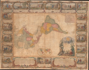
L'Amerique Divisee En Tous Ses Pays Et Etats dressée sur de nouveaux Memoires et sur les derniers Observations.
sold
- Digital Map Information
- Suitable for large format printing
- File Size: 185.45 MB
- File Type: ZIP / TIFF
- ICC color profile embedded
- Delivered instantly via download link
This is a dramatic 1754 east-oriented wall map of the Americas by Jean Janvier and Sebastian G. Longchamps - better known as Voltaire's valet. The dramatic map includes one of cartography's boldest iterations of the Sea of the West. This map appeared at the outset of the French and Indian War (1754 - 1763) and correspondingly details France's bold claims to much of North America. (more details)
American colonies at the outset of the Revolutionary War.
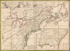
Carte des Possessions des Colonies Anglaises dans le Continent de L'Amérique Septentrionale et Partie de la Louisiane.
sold
- Digital Map Information
- Suitable for large format printing
- File Size: 185.45 MB
- File Type: ZIP / TIFF
- ICC color profile embedded
- Delivered instantly via download link
This is the 1776 edition of Sebastian G. Longchamps's map of eastern North America, published at the outset of the American Revolutionary War (1775 - 1783) to capitalize on popular French interest in the conflict. The map was first issued in 1756, during the French and Indian War (1754 - 1763), but has here been revived with significant new engraving, additional relevant details, and a new title to illustrate the opening theaters of the American Revolution. Key revisions give greater prominence to the individual New England colonies and expand the coastal nomenclature of northern Newfoundland, where France retained valuable fishing privileges despite losing Canada. (more details)