
Loomis, William S. (sold)

William S. Loomis (1840 - July 10, 1914) was an American publisher and businessman. Born in Granville, Massachusetts, Loomis moved to Holyoke, Massachusetts as a young boy. He graduated from Holyoke High School and worked in his father's store. When the American Civil War broke out, Loomis enlisted in B Company, 46th Regiment, Massachusetts Infantry and was promoted to the rank of second lieutenant in January 1863 by Governor John A. Andrews. After the war, Loomis was elected Holyoke town clerk and held the position for a number of years. Loomis bought a share of the Holyoke Transcript, the town's weekly newspaper, from Charles M. Lyman, and began publishing the paper with Edwin L. Kirtland unde the name Loomis and Kirtland. Kirtland sold his shares to William G. Dwight in 1881, and Loomis and Dwight began working on converting the paper from a weekly to a daily. Loomis, however, sold his share of the paper in 1888 to devote himself to the Holyoke Street Railway Company, which he owned. He soon had a street railway line operating in Elmwood as well, and not long after organized the Mt. Tom Railway Company. Loomis resigned as general manager of the Holyoke Street Railway Company in 1912, but retained the presidency. He also was still serving as president of the Mt. Tom Railway COmpany, vice-president of the Holyoke Savings Bank, vice-president of the Holyoke Library Association, and president of the Forestdale Cemetery Association when he died.
Holyoke, published in Holyoke.
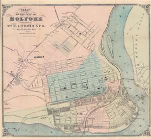
Map of the City of Holyoke.
sold
- Digital Map Information
- Suitable for large format printing
- Full resolution TIFF file
- ICC color profile embedded
- Delivered instantly via download link
This is a c. 1871 William Loomis city plan or map of Holyoke, Massachusetts, a historic mill town on the Connecticut River. Holyoke is located in the famous 'Five Colleges' region of the Pioneer Valley. The 'five' include Amherst College, Hampshire College, Mount Holyoke College, Smith College, and the University of Massachusetts Amherst. Holyoke is divided into wards, shaded a different for easy differentiation. Buildings are illustrated throughout, many of which are labeled, including the grammar school, high school, city hall, numerous businesses, and churches. Three freight canals cut through the city, and the Connecticut River Railroad runs along the Connecticut River. The whole is surrounded by a beautifully engraved border. (more details)
An extremely rare map of Holyoke, Massachusetts published by the owner of the Holyoke Street Railway Company.
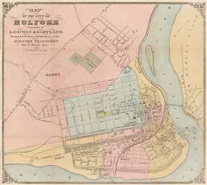
Map of the City of Holyoke.
sold
- Digital Map Information
- Suitable for large format printing
- File Size: 16.58 MB
- File Type: ZIP / TIFF
- ICC color profile embedded
- Delivered instantly via download link
This is a c. 1874 William Loomis and Edwin Kirtland city plan or map of Holyoke, Massachusetts, a historic mill town on the Connecticut River. Holyoke is located in the famous 'Five Colleges' region of the Pioneer Valley, including Amherst College, Hampshire College, Mount Holyoke College, Smith College, and the University of Massachusetts Amherst. Holyoke is divided into wards, each of which is shaded a different color to allow for easy differentiation. Buildings are illustrated throughout the city, many of which are labeled, including the grammar school, high school, city hall, as well as numerous businesses and churches. Three canals cut through the city, and the Connecticut River Railroad traverses a few city wards before reaching running along the bank of the Connecticut River. The whole is surrounded by a beautiful border. (more details)