
Liechtenstern, Joseph Marx von (sold)

Joseph Marx Freyherrn von Liechtenstern (February 12, 1765 - October 10, 1828) was an Austrian nobleman, geographer, and statistician. Coming from an elite family, he was well-educated, studying law before going into government service. He maintained a lifelong passion for geography, statistics, and comparative administration between states (political science avant le mot), and in 1790 founded the Vienna Kosmographische Institut ('Statistical Institute'). The upheavals of the era hampered the group's work; nonetheless, it did produce a steady stream of publications on history and geography, and promoted the use of statistics in public administration. Among other works, in contributed to and completed the influential 1805 Atlas Des Österreichischen Kaiserthums.
Hungary in the consolidated Austrian Empire.
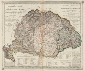
Allgemeine Charte vom Königreiche Ungarn mit Einschluss der Königreiche Croatien und Slavonien dann vom dem Grossfüstenthum Siebenbürgen. / Carte Générale du Royeaume de Hongrie avec les Royeaumes de Croatie et d'Esclavonie contenant aussi le Grand-principauté de Tansilvanie.
sold
- Digital Map Information
- Suitable for large format printing
- File Size: 34.84 MB
- File Type: ZIP / TIFF
- ICC color profile embedded
- Delivered instantly via download link
This is an 1805 Joseph Marx von Liechtenstern map of the Kingdom of Hungary and the Grand Principality of Transylvania. The map and the rare Kipferling atlas it was published in were issued as a celebration and administrative tool for the consolidated Austrian Empire, declared in reaction to Napoleon's First French Empire during the Napoleonic Wars (1803 - 1815). (more details)
An elegant early 19th century world map.
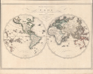
Beide Halbkugeln der Erde : in stereographischer Aequatorialprojection nach des Herrn Freiherrn von Liechtenstern.
sold
- Digital Map Information
- Suitable for large format printing
- Full resolution TIFF file
- ICC color profile embedded
- Delivered instantly via download link
An elegant 1806 world map in two hemispheres by Joseph Wüstinger with outline hand-coloring. It depicts the world with recent discoveries incorporated, including the voyages of Cook and Vancouver. (more details)