
Millar, George Henry (sold)

George Henry Millar (fl. 1780 - 1790) was a British engraver and map publisher active in London during the latter part of the 18th century. Millar published the 1782 New and Universal System of Geography. He is also credited with an early view of the 1775 Battle of Bunker Hill. Most of his work was published between 1782 and 1785, and we have found no earlier or later productions.
One of the earliest obtainable views of the 1775 American Revolutionary War Battle of Bunker Hill.
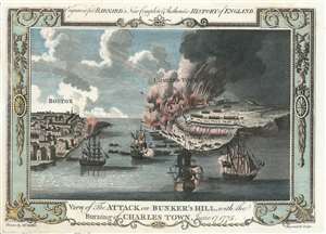
View of the Attack on Bunker's Hill, with the Burning of Charles Town, June 17, 1775.
sold
- Digital Map Information
- Suitable for large format printing
- Full resolution TIFF file
- ICC color profile embedded
- Delivered instantly via download link
One of the earliest obtainable views of the 1775 American Revolutionary War Battle of Bunker Hill. Published in 1783, this view illustrates the June 17, 1775 Battle of Bunker Hill, Boston, one of the first and most significant battles of the American Revolutionary War (1775 - 1783). The view looks east from Boston Harbor. Boston is on the left, Charlestown and Breed's Hill are afire on the right. British naval vessels fill the harbor, while long range cannons bombard Charlestown from Boston. The view is reasonably accurate, suggesting that the artist, 'Mr. Millar', probably George Henry Millar, may have witnessed the battle first hand or drew upon the experience of one who had. (more details)