
Moithey, Maurille Antoine (sold)

Maurille Antoine Moithey (March 24, 1732 - December 12, 1810) was a French mathematician, cartographer, globemaker, game designer, and bookseller active in Paris in the mid to late 18th century. Moithey was born in Paris. He held the post of 'Ingénieur géographe du Roi' and professor of mathematics to the pages of the Prince and Princess of Conti. Throughout his long career as a geographer, he was an ardent spokesman for the 'freedom of the seas', particularly as applied to the English Channel.
One of the first maps to recognize the American Revolution.
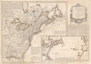
Carte Nouvelle des Possessions Angloises en Amérique dressée pour l'intelligence de la guerre présente et divisée suivant les prétentions des Anglois...
sold
- Digital Map Information
- Suitable for large format printing
- Full resolution TIFF file
- ICC color profile embedded
- Delivered instantly via download link
This is Maurille Antoine Moithey's rare separately issued April 1777 broadside map of the fledgling United States, one of the earliest general maps of the British Colonies to reflect the commencement of the Revolution. Issued in Paris, the map traces events in the early stages of the American Revolutionary War (1775 - 1783) with historical context as far back as the French and Indian War (1754 - 1763). Moithey issued this map to address French interest in the American Revolution - which was riding high at the time. The map predates by several months the 1778 signing of the Treaty of Alliance between France and the emergent United States. (more details)