
Nell, Louis Max (sold)

Louis Max Nell (January 3, 1842 - January 2, 1908) was a German-American surveyor, explorer, publisher, and map maker. Nell was born in Altenkirchen, Germany and studied in Civil Engineering in Coblentz and Berlin. He emigrated to the United States, arriving in New York in 1865. He issues several maps, including maps of New York, New England, and California. He moved to Washington, D.C. in 1870 to work as a civilian contractor for the Corps of Topographical Engineers. He was sent to Colorado as a topographer with Captain George Wheeler's survey expedition from 1871 - 1879. Impressed with Colorado, Nell left the Corps of Topographical Engineers to settle in Denver. Shortly thereafter, he leveraged the wealth of information collected during the Wheeler survey to compile and issue highly detailed and influential commercial maps of the state. His work eclipsed that of his predecessor in Colorado mapping, H. L. Thayer in scope, detail, and regularity of updates. Nell issued 2 map series focused on Colorado entire: The medium format Topographical and Township Map of Colorado, which was issued from about 1880 to 1906; and the large format, Topographical Map of the State of Colorado, issued from 1886 to 1907. In addition to his work in Colorado, he was a member of the Norther Transcontinental Survey from 1882 - 1883. He was also sent to Alabama to complete surveys in 1888 - 1889 under Major Powell. He continued to work as a draftsman at the U.S. Geological Survey office in Colorado until 1907. He died one year later in 1908.
First edition of Nell's important large format map of Colorado.
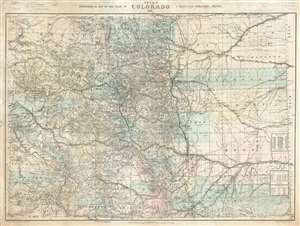
Nell's Topographical Map of the State of Colorado.
sold
- Digital Map Information
- Suitable for large format printing
- File Size: 87.77 MB
- File Type: ZIP / TIFF
- ICC color profile embedded
- Delivered instantly via download link
This is the very rare 1887 first edition of Louis Nell's separate-issue map of Colorado. It is hands down the largest and most detailed map of Colorado to appear after the 1876 statehood. The map painstakingly illustrates topography, names rivers and streams, shows railroads, identifies footpaths, and more. The map is further broken down into counties and Land Office districts. Native American reservations, military reservations, and mining territories are also named. Mountain peaks, many of which have today become popular ski resorts, are named throughout. (more details)
Essential Colorado map.
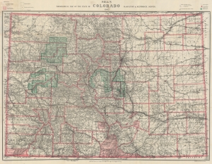
Nell's Topographical Map of the State of Colorado.
sold
- Digital Map Information
- Suitable for large format printing
- File Size: 203.08 MB
- File Type: ZIP / TIFF
- ICC color profile embedded
- Delivered instantly via download link
A beautiful example of the 1902 edition of Louis Nell's important topographical map of Colorado, considered the best commercial map of Colorado at the time of publication. (more details)