
Nicholson, Francis (sold)

Francis Nicholson (fl. c. 1838 - 1848) was a surveyor for the City of New York. Little is known about his life or career working for the city.
Highlights Mount Morris Park, which hosted the Harlem Cultural Festival, known as the Black Woodstock, in 1969.
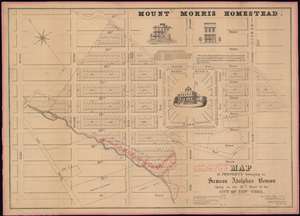
Map of the Property belonging to Samson Adolphus Benson Lying in the 12th War of the City of New-York.
sold
- Digital Map Information
- Suitable for large format printing
- DPI: 600
- File Size: 42.43 MB
- File Type: ZIP / TIFF
- ICC color profile embedded
- Delivered instantly via download link
A fine example Francis Nicholson's rare 1848 cadastral map of the Mount Morris Park historic district - the only specific map of this area to appear in the 19th century. The map depicts the region from Eighth Avenue to Fourth Avenue and from 127th Street to 116th Street. Streets and avenues are identified and all the buildings and city blocks are numbered. Harlem Creek, which has long since been buried under the development of Manhattan, is illustrated. Manuscript notations in red ink illustrate the land holdings of Abraham Bussing, John Bussing, and Adolph Bussing. (more details)