
Nicholson, Walter Lamb (sold)
Walter Lamb Nicholson (1825 - April 13, 1895) was a Scottish-born civil engineer, cartographer, and federal topographer active in Washington, D.C., during the second half of the 19th century, particularly in the production of military and postal maps. Born in Edinburgh, he was the son of the portrait painter William Nicholson (1781 - 1844), a founding member of the Royal Scottish Academy. He attended Edinburgh's high school, where he distinguished himself in languages and mathematics, before studying civil engineering in England and entering employment in the railway industry. In 1851 he emigrated to the United States to work as an assistant engineer on railroads in Kentucky and Arkansas. He joined the United States Coast Survey in Washington in 1856 under Alexander Dallas Bache (1806 - 1867), taking responsibility for preparing the Survey's records and results for publication. During the American Civil War (1861 - 1865), his engineering experience in the South supported the compilation of military maps. His Map of Eastern Virginia, published in 1862, combined geographical information with red overprinting identifying railroads and concentric distance circles centered on Richmond. In 1863, on Bache's recommendation, Nicholson became topographer of the Post Office Department, a position he held for approximately twenty-two years. He developed the department's series of post-route maps, recording post offices, mail connections, and intermediate distances, and supervised work essential to verifying government mileage and distance calculations. His maps included regional and state sheets as well as railway postal diagrams prepared for the Railway Mail Service. Beyond his postal responsibilities, he coordinated the collection of North American elevation data for a joint Smithsonian Institution and Coast Survey project intended to produce a continental contour map; this undertaking passed to the Survey in 1882. A founding member of the Philosophical Society of Washington, Nicholson also participated in scientific investigations with Joseph Henry (1797 - 1878). Following his retirement about 1885, he undertook occasional scientific work despite declining health. He died in Washington on April 13, 1895, at his son-in-law's residence, and was buried in Congressional Cemetery.
Railroads in the Eastern Theater of the American Civil War.
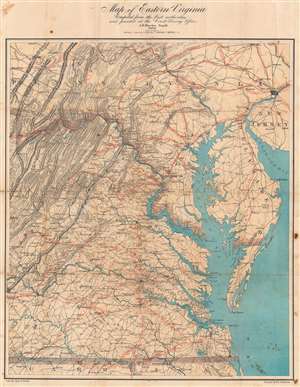
Map of Eastern Virginia.
sold
- Digital Map Information
- Suitable for large format printing
- Full resolution TIFF file
- ICC color profile embedded
- Delivered instantly via download link
This is an 1862 Walter L. Nicholson map of eastern Virginia and the surrounding theater of the American Civil War (1861 - 1865), prepared both to help the public follow military operations and to experiment with color printing at the U.S. Coast Survey. It translates the region's transportation geography into a readily legible network of red-highlighted railroads, with concentric circles highlighting Richmond. The unique immediacy of telegraphic war reporting during the Civil War made maps like Nicholson's a practical necessity for a public following daily news of battles and army movements. (more details)