
Nihon Tōsei Chizu (sold) (日本統制地圖)

Nihon Tōsei Chizu Kabushiki Kaisha (日本統制地圖株式會社; fl. c. 1931 - 1944) was a Tokyo-based publisher of maps of the Japanese home islands and empire.
AKA: 日本統制地圖
Japanese oil prospecting in the East Indies during World War II.
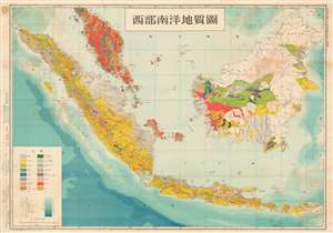
西部南洋地質圖 / Western Ocean Geological Map. / Seibu nan'yō chishitsuzu.
sold
- Digital Map Information
- Suitable for large format printing
- File Size: 49.75 MB
- File Type: ZIP / TIFF
- ICC color profile embedded
- Delivered instantly via download link
An exceptional discovery, this is Ōmura Ichizō's World War II era geological survey of Malay and the East Indies. The survey was completed and published one year after the Japanese conquest of the region in order to assess drilling and mining viability. With a multi-front war in progress, the Japanese needed to acquire as many raw material resources as possible and the geological exploitation of this region was essential to their ambitions. The map depicts from the Malaya Peninsula to southern Java and from Aceh (northwester Sumatra) to North Borneo. Singapore, at the southern tip of Malaya, takes center stage. (more details)