
Painlevé, Léon Louis (sold)

Léon Louis Painlevé (May 22, 1832 - March 8, 1906) was a French engraver and architect active in Paris in the second half of the 19th century. He was born and died in Paris and is described as a lithographer of limited means. He is the father of Paul Prudent Painlevé (1863 - 1933), a noted scientist who became Prime Minister of France.
The first printed example of a Babinet / Mollweide Projection?
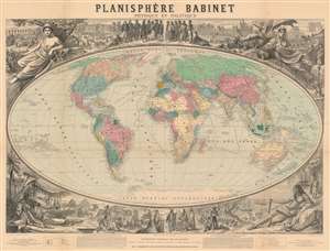
Planisphère Babinet Physique et Politique.
sold
- Digital Map Information
- Suitable for large format printing
- File Size: 192.9 MB
- File Type: ZIP / TIFF
- ICC color profile embedded
- Delivered instantly via download link
A stunning c. 1860 wall-sized map of the world on a Mollweide or Babinet Projection surrounded by elaborate allegorical imagery. Our research suggests this is one of the earliest, if not the earliest, published example of a Mollweide Projection. The map is centered on Europe and is, indeed, Eurocentric, with color coding intended to represent colonial claims around the world. Tracks at sea illustrate popular maritime routes across the Atlantic and to various points, around Africa, and to Australia, China, and the East Indies. Text at bottom center by Victor Adolphe Malte-Brun (1816 - 1889) and Hermann Berghaus (1828 - 1890), the preeminent geographers of the day, praise the usefulness and practicality of the Mollweide / Babinet projection. (more details)