
Petersen, A. (sold)

A. Petersen (fl. c. 1857 - c. 1875) was an engraver for the U.S. Coast Survey and then the U.S. Coast and Geodetic Survey.
Rare, separately issued map of Woods Hole, Cape Cod - near Martha's Vineyard!
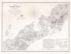
The Harbor of Wood's Hole Massachusetts.
sold
- Digital Map Information
- Suitable for large format printing
- File Size: 13.75 MB
- File Type: ZIP / TIFF
- ICC color profile embedded
- Delivered instantly via download link
This is a rare separately issued 1857 U.S. Coast Survey nautical chart or map of Woods Hole, Massachusetts, near Martha's Vineyard. The map depicts the southwestern tip of Barnstable County, Nonameseset Island, and parts of nearby Naushon Island. Exceptional detail is displayed, down to the level of individual buildings and streets. The Woods Hole blacksmith shop, a 'yellow house,' and the 'new church' are among the sites identified. Woods Hole itself, the passage for ships between Vineyard Sound and Buzzards Bay known for its extremely strong current, is illustrated with numerous depth soundings. Sailing instructions and other practical information for the mariner appear in the lower right. (more details)
Live Oaks Plantation.
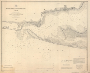
Entrance to Pensacola Bay Florida.
sold
- Digital Map Information
- Suitable for large format printing
- File Size: 47.52 MB
- File Type: ZIP / TIFF
- ICC color profile embedded
- Delivered instantly via download link
This is an 1882 U.S. Coast and Geodetic Survey nautical map of the entrance to Pensacola Bay, Florida. (more details)